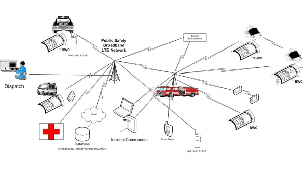
Future First Responders and FirstNet: Response to a multiple-vehicle accident (MVA) scenario
What is in this article?
Scenario: Response resources requested
Dispatch notifies the chief—on his tablet—which the mutual-aid assets are ready to respond and requests authorization to send those assets to the scene following the MA preplan. The chief then looks at the total responding assets and determines that the MA level 2 alarm for the box area is needed. The chief is informed that the following are identified as being ready for responding and are properly manned.
- Two rescue apparatus requested
- One fire apparatus requested
- Two tankers requested
The chief acknowledges the MA level 2 request, and this is automatically conveyed to dispatch, as well as to the Home Monitors for both the initially responding fire department and the MA fire departments.
Also, the EMS icon—automatically highlighted, based on the preplans selected already—prepares the following actions:
- Two ambulances requested
- MobileAir alerted
- Estimate of number injured that will be sent
The chief also selects the public-utility icon and informs utility officials about the situation via the following steps:
- Utility-pole damage selected
- Location of the chief is shared, which is sent to aid in dispatching utility personnel, and the estimated location of the damaged pole
The chief acknowledges, and dispatch replays MA request following preplan guidelines.
A visual map informs the chief and dispatch when the MA apparatus are en route. Each apparatus is identified and has a color code that indicates if it is responding or available. The number and type of personnel en route—along with the ETA for each—is included.
From his local command post, the chief controls the camera on his vehicle and pans the area, enabling a 30-second video clip to be sent to all those responding. The video clip is uploaded to the 911 center and is broadcast to all responding units
Live video from chief’s vehicle continues, with a high-definition feed being transmitted to the 911 center and responding units that are within 2 miles of incident. Lower-resolution feeds are provided to all other responding units, including mutual-aid units. Incident updates regarding hazards also are displayed, including wind direction.
Based on the preplan, a map for the incident area is displayed on all apparatus, providing updated information and overlaying fire-plug locations, hazard-material locations and other key attributes for the area, such as weather. If conditions are different than reported, the officer in the first apparatus to arrive updates the data. This update is then sent to all involved with the incident.
As each apparatus approaches the incident area, its corresponding icon in the ICS application changes from solid to flashing. The chief is able to acknowledge the asset, and the icon changes from flashing to red, indicating it is on scene. To acknowledge the asset, the chief uses the ICS tablet and taps each approaching apparatus and defines where they should be positioned: where to stage, manpower assignments, following seat positions along with ingress and egress considerations. The requested staging area, as well as manpower assignments, can be adjusted based on skill levels and the incident situation.
The chief then uses the ICS tablet to select the location for Police or Fire Police to block off the additional civilian traffic. This is relayed to Police and dispatch. Additionally, the primary and secondary roads to the incident are highlighted for closure using a street-closure application.
The chief then uses the incident map to select the location of each MVA vehicle and the type of vehicle class that they are (passenger, truck, fuel). He then assigns each arriving apparatus to a vehicle involved in the crash. This information is then displayed to the responding units and personnel that are en route.
The chief also uses the ICS tablet to request initiation of an evacuation procedure, following a preplan. Parameters are defined based on the location of propane truck and the preplan steps. The initial perimeter for evacuation is defined based on the hazmat manual, and a geo-fencing circle is created from the center of the approximate location of the LP truck.
To do this, the chief executes the following steps on the ICS tablet:
- Map of current location appears, with roads
- Chief touches with quick pull down windows identifying approximately where each of the crashed vehicles are and their type (truck, fuel, passenger)
- Location of vehicles is displayed to responding units and personnel
- Identifies primary road-closure locations (uploaded to Police and Fire Police)
- Requests that the evacuation-procedure possibility be initiated, with the parameter defined based on the location of the propane truck
- Designate where to stage each apparatus, manpower for helping, ingress and egress considerations
This request is relayed to the Police and the department of public works (DPW). Police and DPW acknowledge the request and inform the chief that assets are being deployed. Police and Fire Police later update this information, indicating which intersections are manned for traffic diversion and which ones are not.
As part of the preplan, the prioritization of DPW on the LTE communication system is elevated for the response. Additionally Fire Police are dispatched to a preplan landing-zone area for Medevac and secure the area, including placement of cones to define the landing zone.
Medevac gets landing coordinates (waypoint) via wireless, as well as a video feed and the current CID information.
Part of the personnel information reported includes the rescue/fire personnel and which seat they occupy in an arriving vehicle. RFID tags embedded into their Personal Protection Equipment (PPE), along with pairing for seat assignments, are used.
As part of the accountability program, when the fire/rescue personnel enter the apparatus they are identified as being in the apparatus either when reporting to the scene or returning from the scene. When they exit the apparatus during a call, the chief is informed that they are on the scene.
The use of Body Worn Computers (BWC) integrated into the PPE equipment provides a host of communication and information capabilities. BWC systems outfitted with LTE capability (shown in figure 4a) are on every fire/rescue personnel’s PPE.
The BWC is able to provide telemetry feeds to the chief when personnel don their gear. The telemetry feed not only establishes a communication link, but it also activates the biometric and environmental sensors that are worn. The BWC is an intrinsically safe (Class1 Division1) device. EMS and Police use similar BWCs as part of the communication ecosystem.
(a)
(b)
Figure 4: Body Worn LTE Device (class1dev1) (a) BWC with LTE radio (b) BWC with LTE radio linking with SCBA with augmented display. Click the images to enlarge.
Information that can be displayed on the BWC includes video feeds from other first responders, infrared-camera display, sensor data, building schematics and the relative position of other rescue personnel.
Figure 4b shows the self-contained breathing apparatus (SCBA) mask outfitted with an augmented display that will show a host of tactical data to the firefighter. The information displayed on the SCBA mask can be the same that is displayed the BWC display, but the information will be shown on the SCBA augmented display once the SCBA mask is donned.
All the information is displayed on the BWC or SCBA augmented displays is controlled by the BWC on the PPE or by remote control from the chiefs ICS tablet.
Using the public-safety LTE network, officers, drivers and fire personnel are therefore able to have a holistic situation report, as well as task assignments before arriving on scene, which speeds the response. As part of the situation information, the video feed and clip are displayed in the apparatus using the CID in several locations, along with other tactical feeds for improved information. The officer in the apparatus also has a read-only display of the chief’s ICS tablet with the ability to send updated information about the status of arriving apparatus.


And the final scenerio, the
And the final scenerio, the chief receives a lawsuit on a stack of paper because he arrived on scene within minutes of it being reported and played on his tablet, messed with some electronics in the back of his SUV and played with a camera on the SUV while family members were left bleeding and dying. Just because we have all this technology that can do all kinds of neat and wonderful things doesn’t mean we should. Based on the story line given, it would seem that every resource, especially the chief’s vehicle should include an IT Technologist to run all of the stuff on board and keep track of all the data and information so the chief doesn’t work the scene with his nose pointed at a tablet. Does the chief really need to know that firefighter Jones is in the right rear seat of the second in engine? Does he need to know exactly when Jones stepped off the engine? If the chief doesn’t care about that minutiae I bet the lawyer will want to know.