New technology improves firefighter location
What is in this article?
New technology improves firefighter location
(Ed.: This article originally appeared in print as "Where there's smoke, there's trouble.")
Because of the inherent danger and physical demands, firefighting is a high-anxiety occupation. Every second counts as firefighters work frantically to minimize damage to property and — more important — preserve the well-being of those living in the immediate area.
But sometimes firefighters and other first responders encounter situations in which they need to be saved as much as the occupants of a burning building, after becoming disoriented or lost. Typical protocol calls for firefighters to have a partner with them at all times, but these partners can get separated, according to Charles Werner, fire chief for the city of Charlottesville, Va.
The problem could be the result of a structural issue — for example, the collapse of a wall, floor or ceiling — a physical injury or other unwanted circumstances that cause a firefighter to lose his bearings. Whatever the reason, the realization is terrifying both for the distressed firefighter and everyone else at the scene, Werner said.
"When you get into zero visibility, and you get disoriented, it's probably one of the scariest feelings you'll ever have," Werner said, noting that he was in such a precarious scenario once during his career. "You're in an intolerable environment — it's literally unsurvivable without protection, but you only have a limited amount of air, and depending on how hot it is, you can only stand the heat so long.
"And, when you're a fire chief, it's your worst nightmare — you realize that you only have minutes in a lot of cases to actually save the firefighter who is lost. It takes everything that you've got and everybody that's on the scene to make that happen."
To date, there is little technology in the field that is able to help. Emergency buttons on LMR radios can alert everyone on the scene that there is a "man down," but the distressed firefighter typically must be within earshot of another crew member or needs to be able to describe his location to an incident commander, who can deploy a Rapid Intervention Team (RIT) to find the firefighter.
However, a disoriented or unconscious firefighter can provide little information, meaning the RIT members are left to play a guessing game — in cloud of thick, acrid smoke — that normally starts at the last known position of the downed firefighter. GPS has become an increasingly common feature on LMR radios, but the technology usually does not work inside a building, where a satellite does not have a clear path to the radio. In addition, GPS only provides longitude and latitude (X and Y) coordinates; one of the biggest location challenges is determining which floor the firefighter is on in a multi-story building, i.e.,the user's altitude (Z coordinate).
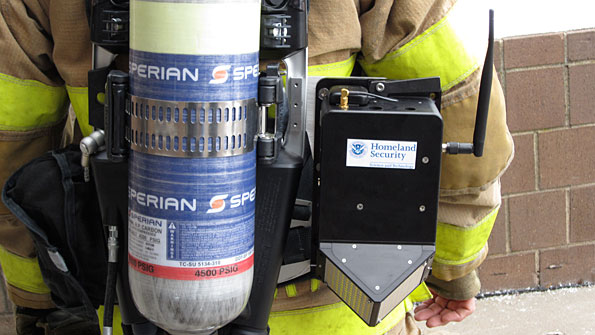
Recently, the U.S. Department of Homeland Security's directorate of science and technology (DHS S&T) has invested considerable resources to develop a viable solution to this life-and-death quandary. After years of work, officials are hopeful they have found the answer with the Geospatial Location Accountability and Navigation System for Emergency Responders (GLANSER) technology, which is designed to provide three-dimensional location data for firefighters without interfering with their normal operations.
SIDEBAR: How GLANSER works
If tested and commercialized successfully, the technology could be a popular tool in the firefighting community, because it addresses a longtime problem, Werner said.
"That's probably the fire chief's worst nightmare — to have a lost firefighter and not know where he or she is," he said. "To be able to resolve that issue and rescue a firefighter probably would be one of — if not the — most important technologies that we'll put in place.


Are you kidding? “GPS only
Are you kidding? “GPS only provides longitude and latitude (X and Y) coordinates?” REALLY?
Two questions: How many variations of lat/long are there and why are none of them the STANDARD for ground responders? What is the U.S. civil standard grid reference system? Third question, why?
It’s just sad. Non-standards based approach by S&T will mean non-interoperability for many more years to come. Hose fittings all over again but in a technological sense.
To minimize operational friction during all phases of the emergency management lifecycle, but especially during the response phase, first responders and others (including military assets supporting civil authorities) require the ability to use and exchange standardized map coordinates. The lack of a similar, standardized procedure by state, local, and many Federal Agencies is a critical deficiency in U.S. consequence management.
Really it’s the first step in
Really it’s the first step in using this technology. Why criticize something you have never tried. It’s not a finished product and in the next 2-3 years it will likely change again. Relax.
Well, first off, GPS really
Well, first off, GPS really is only accurate for X and Y coordinates and provides questionable altitude information. Since satellites are liable to be anywhere along the horizon at any time, altitude performance is not effective and the final point, stated in the article, is that GPS does not work well in buildings – especially high-rises.
Agreed, though, that the data should still be transmitted in a standardized way, or even better, open-source so that while RF encryption still secures the data, the data can be read by authorized people such as developers who can build their technologies to interoperate based off of the same communications protocol.
If GPS only provides long.
If GPS only provides long. lat. (x,y) data and not altitude data, (z axis) why is it used in aviation? Do your due diligence Donny.