https://urgentcomm.com/wp-content/themes/ucm_child/assets/images/logo/footer-new-logo.png
  • Home
  • News
  • Multimedia
    • Back
    • Multimedia
    • Video
    • Podcasts
    • Galleries
    • IWCE’s Video Showcase
    • Product Guides
  • Commentary
    • Back
    • Commentary
    • Urgent Matters
    • View From The Top
    • All Things IWCE
    • Legal Matters
  • Resources
    • Back
    • Resources
    • Webinars
    • White Papers
    • Reprints & Reuse
  • IWCE
    • Back
    • IWCE
    • Conference
    • Special Events
    • Exhibitor Listings
    • Premier Partners
    • Floor Plan
    • Exhibiting Information
    • Register for IWCE
  • About Us
    • Back
    • About Us
    • Contact Us
    • Advertise
    • Terms of Service
    • Privacy Statement
    • Cookie Policy
  • Related Sites
    • Back
    • American City & County
    • IWCE
    • Light Reading
    • IOT World Today
    • Mission Critical Technologies
    • TU-Auto
  • In the field
    • Back
    • In the field
    • Broadband Push-to-X
    • Internet of Things
    • Project 25
    • Public-Safety Broadband/FirstNet
    • Virtual/Augmented Reality
    • Land Mobile Radio
    • Long Term Evolution (LTE)
    • Applications
    • Drones/Robots
    • IoT/Smart X
    • Software
    • Subscriber Devices
    • Video
  • Call Center/Command
    • Back
    • Call Center/Command
    • Artificial Intelligence
    • NG911
    • Alerting Systems
    • Analytics
    • Dispatch/Call-taking
    • Incident Command/Situational Awareness
    • Tracking, Monitoring & Control
  • Network Tech
    • Back
    • Network Tech
    • Interoperability
    • LMR 100
    • LMR 200
    • Backhaul
    • Deployables
    • Power
    • Tower & Site
    • Wireless Networks
    • Coverage/Interference
    • Security
    • System Design
    • System Installation
    • System Operation
    • Test & Measurement
  • Operations
    • Back
    • Operations
    • Critical Infrastructure
    • Enterprise
    • Federal Government/Military
    • Public Safety
    • State & Local Government
    • Training
  • Regulations
    • Back
    • Regulations
    • Narrowbanding
    • T-Band
    • Rebanding
    • TV White Spaces
    • None
    • Funding
    • Policy
    • Regional Coordination
    • Standards
  • Organizations
    • Back
    • Organizations
    • AASHTO
    • APCO
    • DHS
    • DMR Association
    • ETA
    • EWA
    • FCC
    • IWCE
    • NASEMSO
    • NATE
    • NXDN Forum
    • NENA
    • NIST/PSCR
    • NPSTC
    • NTIA/FirstNet
    • P25 TIG
    • TETRA + CCA
    • UTC
Urgent Communications
  • NEWSLETTER
  • Home
  • News
  • Multimedia
    • Back
    • Video
    • Podcasts
    • Omdia Crit Comms Circle Podcast
    • Galleries
    • IWCE’s Video Showcase
    • Product Guides
  • Commentary
    • Back
    • All Things IWCE
    • Urgent Matters
    • View From The Top
    • Legal Matters
  • Resources
    • Back
    • Webinars
    • White Papers
    • Reprints & Reuse
    • UC eZines
    • Sponsored content
  • IWCE
    • Back
    • Conference
    • Why Attend
    • Exhibitor Listing
    • Floor Plan
    • Exhibiting Information
    • Join the Event Mailing List
  • About Us
    • Back
    • About Us
    • Contact Us
    • Advertise
    • Cookie Policy
    • Terms of Service
    • Privacy Statement
  • Related Sites
    • Back
    • American City & County
    • IWCE
    • Light Reading
    • IOT World Today
    • TU-Auto
  • newsletter
  • In the field
    • Back
    • Internet of Things
    • Broadband Push-to-X
    • Project 25
    • Public-Safety Broadband/FirstNet
    • Virtual/Augmented Reality
    • Land Mobile Radio
    • Long Term Evolution (LTE)
    • Applications
    • Drones/Robots
    • IoT/Smart X
    • Software
    • Subscriber Devices
    • Video
  • Call Center/Command
    • Back
    • Artificial Intelligence
    • NG911
    • Alerting Systems
    • Analytics
    • Dispatch/Call-taking
    • Incident Command/Situational Awareness
    • Tracking, Monitoring & Control
  • Network Tech
    • Back
    • Cybersecurity
    • Interoperability
    • LMR 100
    • LMR 200
    • Backhaul
    • Deployables
    • Power
    • Tower & Site
    • Wireless Networks
    • Coverage/Interference
    • Security
    • System Design
    • System Installation
    • System Operation
    • Test & Measurement
  • Operations
    • Back
    • Critical Infrastructure
    • Enterprise
    • Federal Government/Military
    • Public Safety
    • State & Local Government
    • Training
  • Regulations
    • Back
    • Narrowbanding
    • T-Band
    • Rebanding
    • TV White Spaces
    • None
    • Funding
    • Policy
    • Regional Coordination
    • Standards
  • Organizations
    • Back
    • AASHTO
    • APCO
    • DHS
    • DMR Association
    • ETA
    • EWA
    • FCC
    • IWCE
    • NASEMSO
    • NATE
    • NXDN Forum
    • NENA
    • NIST/PSCR
    • NPSTC
    • NTIA/FirstNet
    • P25 TIG
    • TETRA + CCA
    • UTC
acc.com

Incident Command/Situational Awareness


News

Carbyne integrates Edgybees to overlay mapping on real-time aerial video

Carbyne integrates Edgybees to overlay mapping on real-time aerial video

  • Written by Donny Jackson
  • 18th July 2021

Cloud-based 911 solution provider Carbyne this week announced its integration with Edgybees, which provides software that overlays mapping enhancements on real-time video being streamed to 911 or command center in real time, so public safety and decision makers can better understand the challenges faced during an emergency.

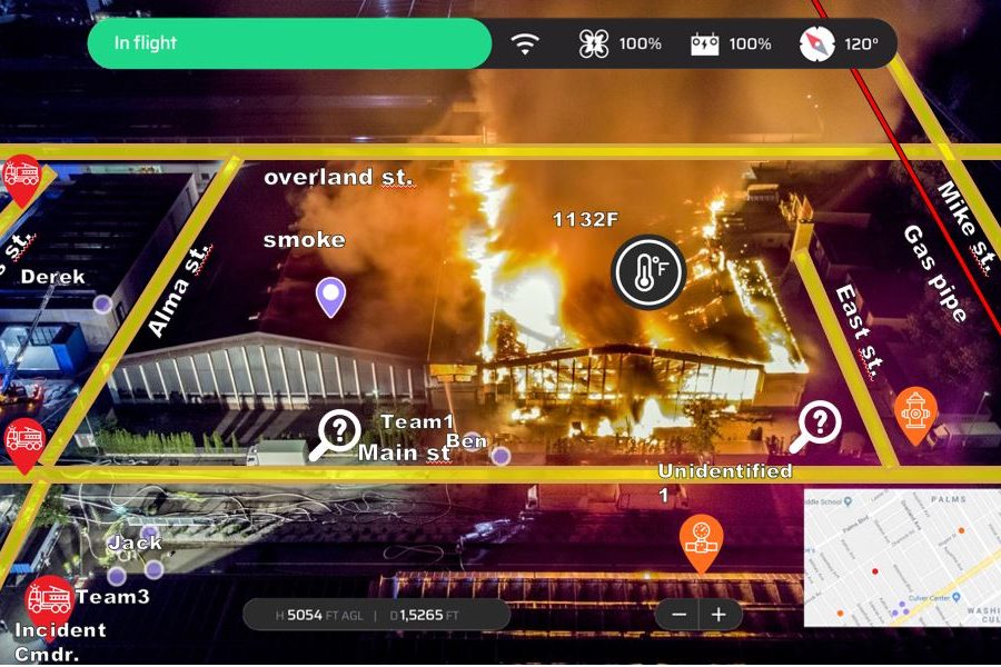
Edgybees CEO and co-founder Adam Kaplan said that aerial video—from drones, helicopters, planes or satellite—increasingly is being used by response agencies when emergencies occur, but the raw footage is not always particular helpful, especially when disasters like flooding make the landscape unrecognizable.

“People are spending tons of money on drones, satellites, planes and things like this,” Kaplan said during an interview with IWCE’s Urgent Communications. “The end result is lots of images where people have no idea what they’re looking at.

“We’re able to overlay data on top of real-time video, to [help first responders] understand situational awareness from the air. We take the data and show you where the streets are and where people are trapped in their buildings. All of that data is being relayed in real time from the video stream to the ground control station … What happens with our software is that it’s taking all of the data and contextualizing the video, all in real time.”

Moti Elkaim, Carbyne’s head of marketing, said that the Edgybees solution brings “tremendous potential and power” to public-safety answering points (PSAPs). Perhaps just as important, the functionality is being added to the Carbyne Universe offering without requiring telecommunicators to look at yet another new screen in their work stations.

“Because our platform and solutions have open APIs, we have the ability to seamlessly integrate Edgybees into the UI [user interface] of Carbyne,” Elkaim said during an interview with IWCE’s Urgent Communications. “The call-taker now doesn’t have to navigate multiple screens at the call station to get the drone feed from Edgybees.

“We have an icon on the Universe UI [user interface], and they’re going to click on that to see the drone feeds—through Edgybees—coming in directly to their Carbyne screen. So the operations side from the call-taker’s end is extremely simple; there aren’t any specific actions they need to do, other than to click on the icon to get the feed from the drone.”

And the value of aerial video with Edgybees mapping enhancements does not have to be limited to a call center or command post, according to Elkaim.

“With Universe, we have the ability to share information live with first responders,” he said. “The drone feed and everything that can be seen on the Carbyne UI at the call-taker’s station can be shared live to the MDT [mobile data terminal] or the mobile devices of the first responders en route to the scene.

“Imagine how powerful that is. The layers that Edgybees provides is something unprecedented; we have never seen anything like it. That is why we’re so excited about the partnership—knowing that we can bring these tools to first responders and really increase the response efficiency in ways that we’ve never experienced before.”

Kaplan said that Edgybees software requires satellite reference imagery—“the equivalent of Google Maps”—to provide mapping context to a real-time video stream, assuming appropriate permissions exist from drone unit or other entity taking the footage.

“We use computer vision and AI [artificial intelligence] to image match—in real time—the satellite reference imagery to that video and make sure that the data is being put in the right place,” Kaplan said.

Edgybees has dozens of customers today, including the U.S. Navy and the U.S. Air Force, Kaplan said. The military customers use the Edgybees solution in a similar manner as public-safety customers—for example, agencies responding to California wildfires—but “on a larger scale and with larger aircraft,” he said.

To stream video live, the drone or other aerial vehicle needs some sort of connectivity, typically provided via LTE or other cellular technologies, Kaplan said.

Elkaim said the Edgybees integration is available immediately, although the new functionality will require some additional cost to existing Carbyne customers. For PSAPs that currently do not use either Carbyne or Edgybees, the integrated solution typically could be operational in a matter of days or several weeks, depending largely on the cooperation of the entity providing the aerial video, according to Elkaim and Kaplan.

The fact that this type of integration can be implemented so quickly exemplifies Carbyne’s goal to make new capabilities available to 911 centers in a “simple, seamless workflow that can be installed immediately in any call center around the country with zero downtime to existing operations and zero interruption,” Elkaim said.

“Our industry has been talking about next-generation 911, and what we always like to say is that we deliver on the industry’s promise,” Elkaim said.

“Carbyne keeps looking for innovative ways to increase situational awareness and response efficiency, collaborating with Edgybees and the other partnerships that we’ve announced. Once again, it amplifies our mission to really advance public safety to where it should be—really delivering all of the essential capabilities that we need to right now.”


Tags: homepage-featured-4 Applications Artificial Intelligence Companies Coverage/Interference Dispatch/Call-taking Drones/Robots Federal Government/Military Funding Incident Command/Situational Awareness Internet of Things Interoperability IoT/Smart X Long Term Evolution (LTE) News NG-911 Public Safety Public-Safety Broadband/FirstNet Regional Coordination Software State & Local Government Subscriber Devices System Design System Installation System Operation Tracking, Monitoring & Control Video Virtual/Augmented Reality Wireless Networks News

Most Recent


  • AT&T becoming a “public-safety company” with FirstNet, NG911 work, exec says
    AT&T has long been one of the greatest consumer communications brands in the world, but the carrier is beginning to become “a public-safety company” through its first-responder-centric efforts in the development of FirstNet and next-generation 911 (NG911) networks, according to Scott Agnew, the new COO of AT&T’s FirstNet team. Two weeks ago, AT&T executives revealed […]
  • U.S. government plans to block all tech exports to Huawei–reports
    The Biden administration is weighing a plan to block the export of all US-sourced technologies to Huawei – the latest escalation in Washington’s years-long campaign to throttle the Chinese firm. The new bans, first reported by Financial Times (paywall applies), would likely fall most heavily on firms such as Intel and Qualcomm that sell Huawei server and […]
  • Command-injection bug in Cisco industrial gear opens devices to complete takeover
    A security vulnerability has been found in Cisco gear used in data centers, large enterprises, industrial factories, power plants, manufacturing centers, and smart city power grids that could allow cyberattackers unfettered access to these devices and broader networks. In a report published on Feb. 1, researchers from Trellix revealed the bug, one of two vulnerabilities discovered that […]
  • AR-based next-gen maps aim to rebalance detail and simplicity
    Every sat-nav user is familiar with the chagrin of missing their turn because the map’s lines and circles don’t resemble the real world. Yandex is blaming maps, not users, for these errors. At its annual conference in December, the company presented its re-designed maps boasting natural-looking 3D objects such as trees, bus stops, colored buildings, […]

Leave a comment Cancel reply

To leave a comment login with your Urgent Comms account:

Log in with your Urgent Comms account

Or alternatively provide your name, email address below:

Your email address will not be published. Required fields are marked *

Related Content

  • Cloud-based Carbyne earns streaming video patent, positions platform as a step toward NG911
  • Carbyne partners with CentralSquare to offer integrated 911 portfolios
  • Mark43 partners with Carbyne to bring cloud-based call-handling, dispatching package to 911 sector
  • Carbyne integrates Edgybees to overlay mapping on real-time aerial video
    Newcomers to U.S. 911 space cite advantages of cloud use for PSAPs

Commentary


How 5G is making cities safer, smarter, and more efficient

26th January 2023

3GPP moves Release 18 freeze date to March 2024

18th January 2023

Do smart cities make safer cities?

  • 1
6th January 2023
view all

Events


UC Ezines


IWCE 2019 Wrap Up

13th May 2019
view all

Twitter


UrgentComm

AT&T becoming a “public-safety company” with FirstNet, NG911 work, exec says dlvr.it/Sj8FXL

9th February 2023
UrgentComm

Command-injection bug in Cisco industrial gear opens devices to complete takeover dlvr.it/Sj6X3l

8th February 2023
UrgentComm

AR-based next-gen maps aim to rebalance detail and simplicity dlvr.it/Sj4gdM

7th February 2023
UrgentComm

Vodafone UK starts ‘risky’ shift to 5G standalone dlvr.it/Sj4dPJ

7th February 2023
UrgentComm

ChatGPT may be fastest-growing app of all time, UBS Says dlvr.it/Sj4NfL

7th February 2023
UrgentComm

Public-safety coalition renews efforts to secure federal NG911 funding dlvr.it/ShwGfn

4th February 2023
UrgentComm

Newscan: Cyberattacks on DoE national labs draw lawmaker scrutiny dlvr.it/Shvpw3

3rd February 2023
UrgentComm

The shine begins to wear off 5G private wireless dlvr.it/Shth0P

3rd February 2023

Newsletter

Sign up for UrgentComm’s newsletters to receive regular news and information updates about Communications and Technology.

Expert Commentary

Learn from experts about the latest technology in automation, machine-learning, big data and cybersecurity.

Business Media

Find the latest videos and media from the market leaders.

Media Kit and Advertising

Want to reach our digital and print audiences? Learn more here.

DISCOVER MORE FROM INFORMA TECH

  • American City & County
  • IWCE
  • Light Reading
  • IOT World Today
  • Mission Critical Technologies
  • TU-Auto

WORKING WITH US

  • About Us
  • Contact Us
  • Events
  • Careers

FOLLOW Urgent Comms ON SOCIAL

  • Privacy
  • CCPA: “Do Not Sell My Data”
  • Cookie Policy
  • Terms
Copyright © 2023 Informa PLC. Informa PLC is registered in England and Wales with company number 8860726 whose registered and Head office is 5 Howick Place, London, SW1P 1WG.