https://urgentcomm.com/wp-content/themes/ucm_child/assets/images/logo/footer-new-logo.png
  • Home
  • News
  • Multimedia
    • Back
    • Multimedia
    • Video
    • Podcasts
    • Galleries
    • IWCE’s Video Showcase
    • IWCE 2022 Winter Showcase
    • IWCE 2023 Pre-event Guide
  • Commentary
    • Back
    • Commentary
    • Urgent Matters
    • View From The Top
    • All Things IWCE
    • Legal Matters
  • Resources
    • Back
    • Resources
    • Webinars
    • White Papers
    • Reprints & Reuse
  • IWCE
    • Back
    • IWCE
    • Conference
    • Special Events
    • Exhibitor Listings
    • Premier Partners
    • Floor Plan
    • Exhibiting Information
    • Register for IWCE
  • About Us
    • Back
    • About Us
    • Contact Us
    • Advertise
    • Terms of Service
    • Privacy Statement
    • Cookie Policy
  • Related Sites
    • Back
    • American City & County
    • IWCE
    • Light Reading
    • IOT World Today
    • Mission Critical Technologies
    • TU-Auto
  • In the field
    • Back
    • In the field
    • Broadband Push-to-X
    • Internet of Things
    • Project 25
    • Public-Safety Broadband/FirstNet
    • Virtual/Augmented Reality
    • Land Mobile Radio
    • Long Term Evolution (LTE)
    • Applications
    • Drones/Robots
    • IoT/Smart X
    • Software
    • Subscriber Devices
    • Video
  • Call Center/Command
    • Back
    • Call Center/Command
    • Artificial Intelligence
    • NG911
    • Alerting Systems
    • Analytics
    • Dispatch/Call-taking
    • Incident Command/Situational Awareness
    • Tracking, Monitoring & Control
  • Network Tech
    • Back
    • Network Tech
    • Interoperability
    • LMR 100
    • LMR 200
    • Backhaul
    • Deployables
    • Power
    • Tower & Site
    • Wireless Networks
    • Coverage/Interference
    • Security
    • System Design
    • System Installation
    • System Operation
    • Test & Measurement
  • Operations
    • Back
    • Operations
    • Critical Infrastructure
    • Enterprise
    • Federal Government/Military
    • Public Safety
    • State & Local Government
    • Training
  • Regulations
    • Back
    • Regulations
    • Narrowbanding
    • T-Band
    • Rebanding
    • TV White Spaces
    • None
    • Funding
    • Policy
    • Regional Coordination
    • Standards
  • Organizations
    • Back
    • Organizations
    • AASHTO
    • APCO
    • DHS
    • DMR Association
    • ETA
    • EWA
    • FCC
    • IWCE
    • NASEMSO
    • NATE
    • NXDN Forum
    • NENA
    • NIST/PSCR
    • NPSTC
    • NTIA/FirstNet
    • P25 TIG
    • TETRA + CCA
    • UTC
Urgent Communications
  • NEWSLETTER
  • Home
  • News
  • Multimedia
    • Back
    • Video
    • Podcasts
    • Omdia Crit Comms Circle Podcast
    • Galleries
    • IWCE’s Video Showcase
    • IWCE 2023 Pre-event Guide
    • IWCE 2022 Winter Showcase
  • Commentary
    • Back
    • All Things IWCE
    • Urgent Matters
    • View From The Top
    • Legal Matters
  • Resources
    • Back
    • Webinars
    • White Papers
    • Reprints & Reuse
    • UC eZines
    • Sponsored content
  • IWCE
    • Back
    • Conference
    • Why Attend
    • Exhibitor Listing
    • Floor Plan
    • Exhibiting Information
    • Join the Event Mailing List
  • About Us
    • Back
    • About Us
    • Contact Us
    • Advertise
    • Cookie Policy
    • Terms of Service
    • Privacy Statement
  • Related Sites
    • Back
    • American City & County
    • IWCE
    • Light Reading
    • IOT World Today
    • TU-Auto
  • newsletter
  • In the field
    • Back
    • Internet of Things
    • Broadband Push-to-X
    • Project 25
    • Public-Safety Broadband/FirstNet
    • Virtual/Augmented Reality
    • Land Mobile Radio
    • Long Term Evolution (LTE)
    • Applications
    • Drones/Robots
    • IoT/Smart X
    • Software
    • Subscriber Devices
    • Video
  • Call Center/Command
    • Back
    • Artificial Intelligence
    • NG911
    • Alerting Systems
    • Analytics
    • Dispatch/Call-taking
    • Incident Command/Situational Awareness
    • Tracking, Monitoring & Control
  • Network Tech
    • Back
    • Cybersecurity
    • Interoperability
    • LMR 100
    • LMR 200
    • Backhaul
    • Deployables
    • Power
    • Tower & Site
    • Wireless Networks
    • Coverage/Interference
    • Security
    • System Design
    • System Installation
    • System Operation
    • Test & Measurement
  • Operations
    • Back
    • Critical Infrastructure
    • Enterprise
    • Federal Government/Military
    • Public Safety
    • State & Local Government
    • Training
  • Regulations
    • Back
    • Narrowbanding
    • T-Band
    • Rebanding
    • TV White Spaces
    • None
    • Funding
    • Policy
    • Regional Coordination
    • Standards
  • Organizations
    • Back
    • AASHTO
    • APCO
    • DHS
    • DMR Association
    • ETA
    • EWA
    • FCC
    • IWCE
    • NASEMSO
    • NATE
    • NXDN Forum
    • NENA
    • NIST/PSCR
    • NPSTC
    • NTIA/FirstNet
    • P25 TIG
    • TETRA + CCA
    • UTC
acc.com

content


Bringing CAD into the field

Bringing CAD into the field

Systems evolve to offer advanced data capabilities to first responders at the scene
  • Written by Urgent Communications Administrator
  • 1st November 2004

Police officers, firefighters and emergency medical technicians are hungry for more and better information in the field. But while traditional mobile data systems offer messaging and some data-lookup capabilities, first responders want a broader range of functions, similar to the functions that dispatchers can access from their consoles. Specifically, they want onscreen maps, navigation help and full details about the incident to which they are responding.

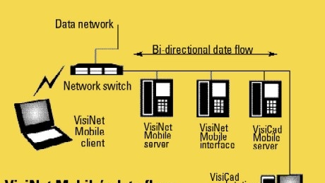
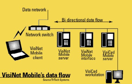
That’s why TriTech Software Systems developed VisiNet Mobile, an in-vehicle companion to its VisiCAD Command computer-aided dispatch system.

“Our customers were saying, ‘You’ve got this great CAD system; why can’t you extend it into the field? We need more data. We need maps,’” said TriTech CEO Chris Malone, whose San Diego-based firm has sold CAD software for public safety since 1991.

San Diego Fire-Rescue Department (SDFD) officials hope to have VisiNet fully functioning on Panasonic Toughbooks installed in 200 vehicles by next June. In Austin, Texas, responders working for Austin-Travis County Emergency Medical Services and the Travis County Sheriff’s Department started using VisiNet Mobile in 100 vehicles this spring. City of Austin police officers and firefighters will soon join them, raising the number of mobile units on the system to about 1000. These agencies have jointly implemented VisiCAD Command in Austin’s Combined Transportation, Emergency and Communications Center (CTECC).

Vendors often incorporate geographic information system (GIS) and routing capabilities in their CAD software. But while operators sitting at dispatch consoles can take advantage of those systems, first responders on the streets don’t have direct access to the same information.

“They need to know, ‘How do I get there, where am I currently, what is the route to the call,’” Malone said, adding that when first responders arrive at an incident, they also need to see what other units are on the scene and where they’re positioned.

TriTech implements GIS software on mobile computers, making maps available to first responders without the need to transmit large graphics files over the air. Global positioning system receivers support automatic vehicle location, keeping users apprised of their own position and the positions of others in the fleet.

While field personnel need to reach no further than the mobile computer’s hard drive for map data, they can also reach across a wireless network for data from other sources. Along with details about a specific incident drawn from the CAD system, additional key information might include data from their agency’s administrative systems, state and local government databases, subscription-based databases and selected sites on the public Internet. A first responder might use the system, for example, to look up information about hazardous materials or access a state Web site for details about prison inmates, Malone said, adding that TriTech has developed its own end-to-end security scheme for the wireless system, which complies with the U.S. government’s FIPS 140-2 standard.

VisiNet Mobile works with a variety of wireless technologies and can switch on the fly between two different networks — for example, between a commercial system and a higher-bandwidth, privately operated 802.11 network. SDFD will use that technique once it gets its system fully running next year. The department will rely mainly on Sprint’s wireless data service, possibly supplemented in some areas by service from Verizon Wireless. At each fire station, however, it will install a Wi-Fi hot spot, and vehicles that drive within range will automatically switch onto that private network, said Susan Infantino, the department’s communications manager.

“If there have been any changes to the maps or to the functionality in the software, it will automatically get downloaded via this hot spot,” Infantino said. “We update our map database every two weeks with new streets, ramps and that kind of thing.”

Firefighters and medical personnel will gain immediate access to these changes, rather than waiting for the department to issue new versions of its printed map books. Eventually, SDFD will add a layer of aerial photographs to its GIS system, and those also will be available on the mobile computers.

“As they pull into a canyon area, they can see the lay of the land from an overhead view,” Infantino said.

This will be especially helpful during rural incidents such as brush fires because the display will combine vehicle positions with real physical features, Malone said.

“It will show the vehicles’ exact locations, regardless of whether there’s a road there,” Malone said.

Public safety agencies in Austin-Travis County are using a Motorola 800 MHz private radio network for day-to-day communications on the VisiNet system. They also have installed 802.11 hot spots at certain public-safety locations, so users can receive software and map updates over the higher-bandwidth network, said Greg Middleton, communications commander and technology manager with Austin-Travis County EMS. The EMS had been using a text-only mobile data system since 1989.

Onboard routing software with up-to-date mapping information helps get first responders to incidents faster, Middleton said. Area agencies expect response time to improve even more next year, when the CTECC will complete an interface between the CAD system and the Intelligent Traffic Management System operated by the Texas Department of Transportation.

The link will feed VisiCAD with real-time data about travel conditions on area roadways, including traffic jams, road construction and accidents. The CAD system will use this information to calculate the quickest path to an incident based not only on permanent factors such as distance and speed limits but also on current traffic flow.

“When it’s rush hour, the CAD system knows there’s a difference,” and it will push that information down to the field crews, Middleton said. “While normally they might have gone driving up the Interstate because that’s what you might think would be the fastest route, they’ll get information that says the Interstate is crawling along at five miles an hour.” An alternative route might cut the response time, “which, certainly for emergency medical services, is a dramatic impact,” he said.

In the future, the EMS might link medical monitoring devices to the mobile system, so technicians can transmit patient data from an ambulance to a hospital, Middleton said. They’re also exploring getting real-time weather radar into the field.

“We’re looking as much as we can to provide more information, to make the job easier for users in the field and provide them with tools to be more effective,” Middleton said.

FIRST Responder takes client-based approach

In TriTech’s VisiNet Mobile system, much of the data that first responders access — aside from mapping information — resides on one or more central servers. FiRST Responder Systems and Technology takes a different approach in its RespondWare Mobile System.

“We have a client-based system,” with data and applications also stored on the mobile computers, said Jeffrey Bean, president and CEO at FiRST Responder Systems in Baton Rouge, La. The company chose this design because of the problems first responders face during emergencies that knock out the communications infrastructure, such as the massive power outage that hit the Northeastern U.S. in August 2003.

Also, “connectivity isn’t consistent all the time,” Bean said. “We wanted the information to reside on the unit in the field so that regardless of the connectivity, the user always has access to the information.” Along with street and road data for navigation purposes, the system offers modules for managing geographically linked data on land parcels, street features, fire hydrants, pipelines, hospitals and buildings with hazardous materials.

When an agency makes changes to information that it stores on a central server, the system transmits those changes to the mobile units. Also, a user who discovers a new condition in the field — for example, a street closed due to a water main break — can upload that information via mobile computer to the server. The server then synchronizes the databases in the other mobiles by transmitting an update over the air.

FiRST Responder designed the system to work with any kind of wireless network, Bean said. “We’re sending small packets of data, just to update the fields in the databases,” so the speed of the network is not important, he said.

Customers traditionally have run RespondWare Mobile on laptop computers permanently installed in their vehicles. Through a recent agreement with Xybernaut Corp. of Fairfax, Va., FiRST Responder is now also offering the system on that company’s Atigo T portable computer, which incorporates GPS along with wireless communications.

Tags: content Operations Public Safety Wireless Networks

Most Recent


  • Verizon
    Verizon, Axon demonstrate benefits of 5G network slicing to support public-safety video
    Verizon and Axon Enterprises this week announced a successful demonstration of 5G network slicing that allowed its network to sustain connectivity performance levels for mission-critical video through Axon Fleet 3 and Axon Respond services. Network slicing is one of the most-anticipated features of the 5G standard for the critical-communications industry, because it allows a network […]
  • Cyberattack closes emergency rooms in three states
    Ardent Health says it was the target of a cyberattack over Thanksgiving, in an incident that shut down the hospital operator’s emergency rooms in three states. The hospital operator, which oversees 30 hospitals in the U.S., said the attack was detected on the morning of Nov. 23 and was identified as a ransomware attack impacting […]
  • General Electric, DARPA hack claims raise national-security concerns
    General Electric and the Defense Advanced Research Projects Agency (DARPA) have reportedly been breached, according to claims on the Dark Web that the organizations’ highly sensitive stolen data is up for sale. A screen capture from the Dark Web ad shows a threat actor named IntelBroker selling access credentials, DARPA-related military information, SQL files, and more. GE confirmed to […]
  • More 2G and 3G shutdowns loom in the U.S.
    UScellular and Cellcom recently set dates to shutter their aging wireless networks. The smaller network operators are following in the footsteps of their bigger, nationwide rivals, which are making similar moves. On its website, UScellular said it would shutter its 3G CDMA network on January 14, 2024. “Major wireless carriers have already shut down their […]

Leave a comment Cancel reply

To leave a comment login with your Urgent Comms account:

Log in with your Urgent Comms account

Or alternatively provide your name, email address below:

Your email address will not be published. Required fields are marked *

Related Content

  • Open-source tools for the IoT ecosystem
  • New Orleans-area 911 center inks multiyear APEX deal with Carbyne to replace call-handling system
  • Bringing CAD into the field
    Newscan: Feds recover millions from pipeline ransom hackers, hint at U.S. Internet tactic
  • Cyber is the new Cold War, and AI is the arms race

Commentary


Land mobile radio (LMR) systems are just as vulnerable to cyberattacks as any other networks used in the public-safety sector. Here’s what to do about it.

  • 1
7th November 2023

September 3GPP Plenary meetings feature Release 18 progress, Release 19 beginnings

13th October 2023

Better technology can help solve the public-safety staffing crisis

26th June 2023
view all

Events


UC Ezines


IWCE 2019 Wrap Up

13th May 2019
view all

Twitter


Newsletter

Sign up for UrgentComm’s newsletters to receive regular news and information updates about Communications and Technology.

Expert Commentary

Learn from experts about the latest technology in automation, machine-learning, big data and cybersecurity.

Business Media

Find the latest videos and media from the market leaders.

Media Kit and Advertising

Want to reach our digital and print audiences? Learn more here.

DISCOVER MORE FROM INFORMA TECH

  • American City & County
  • IWCE
  • Light Reading
  • IOT World Today
  • Mission Critical Technologies
  • TU-Auto

WORKING WITH US

  • About Us
  • Contact Us
  • Events
  • Careers

FOLLOW Urgent Comms ON SOCIAL

  • Privacy
  • CCPA: “Do Not Sell My Data”
  • Cookie Policy
  • Terms
Copyright © 2023 Informa PLC. Informa PLC is registered in England and Wales with company number 8860726 whose registered and Head office is 5 Howick Place, London, SW1P 1WG.