https://urgentcomm.com/wp-content/themes/ucm_child/assets/images/logo/footer-new-logo.png
  • Home
  • News
  • Multimedia
    • Back
    • Multimedia
    • Video
    • Podcasts
    • Galleries
  • Commentary
    • Back
    • Commentary
    • Urgent Matters
    • View From The Top
    • All Things IWCE
    • Legal Matters
  • Resources
    • Back
    • Resources
    • Webinars
    • White Papers
    • Reprints & Reuse
  • IWCE
    • Back
    • IWCE
    • Conference
    • Special Events
    • Exhibitor Listings
    • Premier Partners
    • Floor Plan
    • Exhibiting Information
    • Register for IWCE
  • About Us
    • Back
    • About Us
    • Contact Us
    • Advertise
    • Terms of Service
    • Privacy Statement
    • Cookies Policy
  • Related Sites
    • Back
    • American City & County
    • IWCE
    • Light Reading
    • IOT World Today
    • Mission Critical Technologies
    • Microwave/RF
    • T&D World
    • TU-Auto
  • In the field
    • Back
    • In the field
    • Broadband Push-to-X
    • Internet of Things
    • Project 25
    • Public-Safety Broadband/FirstNet
    • Virtual/Augmented Reality
    • Land Mobile Radio
    • Long Term Evolution (LTE)
    • Applications
    • Drones/Robots
    • IoT/Smart X
    • Software
    • Subscriber Devices
    • Video
  • Call Center/Command
    • Back
    • Call Center/Command
    • Artificial Intelligence
    • NG911
    • Alerting Systems
    • Analytics
    • Dispatch/Call-taking
    • Incident Command/Situational Awareness
    • Tracking, Monitoring & Control
  • Network Tech
    • Back
    • Network Tech
    • Interoperability
    • LMR 100
    • LMR 200
    • Backhaul
    • Deployables
    • Power
    • Tower & Site
    • Wireless Networks
    • Coverage/Interference
    • Security
    • System Design
    • System Installation
    • System Operation
    • Test & Measurement
  • Operations
    • Back
    • Operations
    • Critical Infrastructure
    • Enterprise
    • Federal Government/Military
    • Public Safety
    • State & Local Government
    • Training
  • Regulations
    • Back
    • Regulations
    • Narrowbanding
    • T-Band
    • Rebanding
    • TV White Spaces
    • None
    • Funding
    • Policy
    • Regional Coordination
    • Standards
  • Organizations
    • Back
    • Organizations
    • AASHTO
    • APCO
    • DHS
    • DMR Association
    • ETA
    • EWA
    • FCC
    • IWCE
    • NASEMSO
    • NATE
    • NXDN Forum
    • NENA
    • NIST/PSCR
    • NPSTC
    • NTIA/FirstNet
    • P25 TIG
    • TETRA + CCA
    • UTC
Urgent Communications
  • NEWSLETTER
  • Home
  • News
  • Multimedia
    • Back
    • Video
    • Podcasts
    • Omdia Crit Comms Circle Podcast
    • Galleries
    • IWCE’s Video Showcase
  • Commentary
    • Back
    • All Things IWCE
    • Urgent Matters
    • View From The Top
    • Legal Matters
  • Resources
    • Back
    • Webinars
    • White Papers
    • Reprints & Reuse
    • UC eZines
    • Sponsored content
  • IWCE
    • Back
    • Conference
    • Why Attend
    • Exhibitor Listing
    • Floor Plan
    • Exhibiting Information
    • Join the Event Mailing List
  • About Us
    • Back
    • About Us
    • Contact Us
    • Advertise
    • Terms of Service
    • Privacy Statement
    • Cookies Policy
  • Related Sites
    • Back
    • American City & County
    • IWCE
    • Light Reading
    • IOT World Today
    • TU-Auto
  • newsletter
  • In the field
    • Back
    • Internet of Things
    • Broadband Push-to-X
    • Project 25
    • Public-Safety Broadband/FirstNet
    • Virtual/Augmented Reality
    • Land Mobile Radio
    • Long Term Evolution (LTE)
    • Applications
    • Drones/Robots
    • IoT/Smart X
    • Software
    • Subscriber Devices
    • Video
  • Call Center/Command
    • Back
    • Artificial Intelligence
    • NG911
    • Alerting Systems
    • Analytics
    • Dispatch/Call-taking
    • Incident Command/Situational Awareness
    • Tracking, Monitoring & Control
  • Network Tech
    • Back
    • Cybersecurity
    • Interoperability
    • LMR 100
    • LMR 200
    • Backhaul
    • Deployables
    • Power
    • Tower & Site
    • Wireless Networks
    • Coverage/Interference
    • Security
    • System Design
    • System Installation
    • System Operation
    • Test & Measurement
  • Operations
    • Back
    • Critical Infrastructure
    • Enterprise
    • Federal Government/Military
    • Public Safety
    • State & Local Government
    • Training
  • Regulations
    • Back
    • Narrowbanding
    • T-Band
    • Rebanding
    • TV White Spaces
    • None
    • Funding
    • Policy
    • Regional Coordination
    • Standards
  • Organizations
    • Back
    • AASHTO
    • APCO
    • DHS
    • DMR Association
    • ETA
    • EWA
    • FCC
    • IWCE
    • NASEMSO
    • NATE
    • NXDN Forum
    • NENA
    • NIST/PSCR
    • NPSTC
    • NTIA/FirstNet
    • P25 TIG
    • TETRA + CCA
    • UTC
acc.com

Wireless Networks


Back in a big way

Back in a big way

Non-terrestrial communications are enjoying a revival; here's how they work.
  • Written by Urgent Communications Administrator
  • 1st April 2009

In the 1960s and 1970s, overseas telephone often calls were routed over geostationary satellites. Because a geostationary satellite orbits at 35,800 kilometers (22,250 miles) above the earth and because radio waves travel at the speed of light (3 × 10⁸ m/s), there is a 540 millisecond round-trip delay for satellite telephone calls. Most callers found this delay annoying because the normal interruptions that occur during phone conversations are not recognized immediately by the listener and users tended to talk over each other. As transoceanic fiber optic cables appeared and costs dropped, telephone calls moved from satellite to fiber. Satellite voice communications then became the exclusive domain of the military and ships at sea. Broadcast television took over as the dominant application for commercial satellites and it remains so today.

By the early 1990s there already were millions of cellular phone users, but coverage was limited to urban areas and most third-world countries had no cell phone service at all. Start-ups Iridium and Globalstar recognized the potential for handheld satellite phones and they launched constellations of low earth orbiting (LEO) satellites that would hand off calls between satellites to maintain call continuity. Because these satellites operate between 800 km and 1,500 km above the earth, the round-trip delay is tolerable and both companies achieved some short-term success. In the meantime, terrestrial cellular networks continued to expand and the price of cell phone service dropped rapidly to the point where Iridium and Globalstar could not compete. Both companies declared bankruptcy and are now operating under new ownership, free of the enormous debt that crippled their original operations.

Since 2002, new satellite phone companies have appeared, providing global or regional phone service from geostationary (GEO) satellites operating in the L and S frequency bands (1-3 GHz). These companies include SkyTerra (formerly Mobile Satellite Ventures), Terrestar, and Thuraya. Inmarsat, an early player, continues to provide satellite phone service to ships and to journalists in remote areas.

Because of their modest antenna gain, satellite phones operate at low bit rates (2.4-9.6 kb/s). For high-speed Internet access, higher gain fixed ground terminals operating in the Ku and Ka bands are used. Two commercial examples are HughesNet and WildBlue.

Direct broadcast radio and television satellites such as Sirius XM, DirecTV, Echostar and ICO-G are for the most part one-way communications links and outside the scope of this article.

Satellite orbits


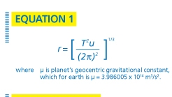
The principles of orbital mechanics were first discovered and explained by Johannes Kepler in the 17th century. Kepler found that the radius of a circular orbit as a function of its period T is given by Equation 1. For a 24-hour circular orbit (86,400 seconds), we find from Equation 1 that the orbit’s radius is 42,241 km. Because the mean earth radius is 6,371 km, the orbital altitude is 35,870 km. In contrast, Iridium’s orbital period is 100 minutes and 28 seconds, the orbital radius is 7,158 km, and the orbital altitude is 787 km.

In general, satellite orbits are elliptical and have some non-zero inclination relative to the equator. Satellite engineers define orbits by six orbital elements referred to as the Keplerian element set. The six orbital elements are the semi-major axis, eccentricity, mean anomaly, argument of perigee, inclination, and right ascension of the ascending node. For definitions of these terms and more information on satellite orbits, see “Satellite Communications,” 4th Ed. by Dennis Roddy.

An orbit of particular interest to communications and broadcasting is the geostationary orbit. A geostationary orbit has a period of 24 hours, travels in the same direction as the earth’s rotation (eastward), and has an inclination of zero degrees. Because the orbital period is the same as the earth’s rotational period, the satellite appears stationary to an observer on earth. The position of a geostationary satellite is specified by its longitude (latitude = 0°) and the pointing angles for an earth terminal (elevation and azimuth) can be calculated from the latitude and longitude of the earth terminal using the Great Circle equations and planar geometry. In practice, there are no truly stationary satellites because gravity from land masses in the northern hemisphere gradually pulls the satellite into a slightly inclined orbit. This inclination causes the satellite to trace a figure eight (as observed from the earth) and periodic station keeping is required to minimize the maximum inclination over time.

Satellite Link Budgets

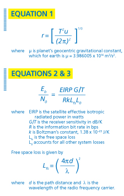
The link budget for a satellite is similar to a terrestrial microwave link except that the downlink (satellite to earth) and uplink (earth to satellite) parameters may differ. Also, unlike microwave receivers, the sensitivity of earth stations is specified by the figure of merit, G/T, which combines receive antenna gain and receiver noise temperature. Noise temperature and noise figure (NF) are related by T = 290(NF-1).

Nearly all modern satellite links are digital and the ratio of energy per bit to noise power spectral density (Eb/N0) is the usual measure of signal-to-noise ratio at the ground receiver. The minimum required Eb/N0 for reliable operation is a function of the maximum tolerable bit-error rate and the particular modulation and coding scheme used. A typical minimum Eb/N0 for the DVB-S standard is 8 dB. The Eb/N0 is calculated using Equations 2 and 3.

Consider a downlink link budget for the WildBlue service. The parameter values and calculations for Eb/N0 are shown in Table 1. Note that a link margin greater than 0 dB is important to account for foliage or precipitation losses.

Satellite Network Architecture

Most satellites are bent pipes, meaning that the uplink signal is received, amplified, translated to a downlink frequency, amplified again, and directed toward the earth using a high-gain antenna. A bent pipe satellite does not demodulate and decode the signal. A gateway station on the ground is necessary to control the satellite and route traffic to and from the satellite and to the Internet. A gateway station also provides the feeder link to route traffic from a landline network (e.g., the Internet) to subscribers. Separate frequency pairs are normally used for the feeder links. Geostationary satellite systems operating in the Ku and Ka bands (12/14 GHz, 17/24 GHz) typically employ geographical spot beams to reuse frequencies across North America. Figure 1 depicts a typical satellite architecture similar to HughesNet or WildBlue.

Some satellites, like Iridium’s, are digital repeaters that demodulate and decode the uplink signal. Iridium also employs satellite cross-links that allow the constellation to operate with fewer gateway stations on the ground. This feature is important for an LEO satellite network because each satellite sees only a small part of the earth and numerous ground stations would otherwise be required. Another important feature of LEO networks is doppler frequency correction. LEO satellites move at such high velocity that doppler shift becomes a problem in the receiver. Either the ground receiver must have a very wide IF bandwidth, which degrades sensitivity, or the satellite transmit frequency must be corrected for doppler shift. In the case of Iridium, the doppler frequency is corrected at the satellite transmitter and receiver after the position of the subscriber radio is known. Correcting doppler at the satellite enables lower-cost handsets.

Jay Jacobsmeyer is president of Pericle Communications Co., a consulting engineering firm located in Colorado Springs, Colo. He holds bachelor’s and master’s degrees in electrical engineering from Virginia Tech and Cornell University, respectively, and has more than 25 years experience as a radio-frequency engineer.

TABLE 1
Wildblue Downlink Link Budget

PARAMETER VALUE UNITS
Satellite EIRP 86 dBm
Frequency 20 GHz
Distance to Satellite (slant range) 39,850 Km
Free Space Loss 210.5 dB
Receiver G/T 14 dB/°K
Boltzman’s Constant -198.6 dBm/°K-Hz
Other System Losses 2 dB
Information Bit Rate 1.544 Mbps
Eb/N0 24.2 dB
(Eb/N0)req 8 dB
Link Margin 16.2 dB
Tags: Wireless Networks

Most Recent


  • FirstNet Authority board approves FY 2023 budget of $358 million
    FirstNet Authority board members yesterday approved a $358 million budget for fiscal year 2023, with more than half of the money being allocated to investments that would be designed to enhance the nationwide public-safety broadband network (NPSBN) being built by AT&T. As in past years, the FirstNet Authority budget for fiscal year 2023—beginning on Oct. […]
  • Intelsat, OneWeb team on in-flight connectivity
    UK-government backed OneWeb and US-based Intelsat are joining forces to offer in-flight connectivity services to airlines, combining the former’s low-Earth-orbit (LEO) satellite service with the latter’s geostationary (GEO) satellites to “harness the power of multi-orbit capabilities.” The companies said they expect the multi-orbit solution to be in service by 2024. Inflight connectivity is certainly an […]
  • What the 6 GHz band might mean to fixed-wireless access
    Fixed-wireless access (FWA) technology is gaining significant interest in the US market, as evidenced by T-Mobile and Verizon collectively adding 816,000 new FWA customers during the second quarter of this year, while Charter Communications and Comcast collectively lost around 21,000 broadband customers. Leichtman Research Group reported that, over the past year, the US broadband industry added a total […]
  • FirstNet PTT technical progress highlighted by AT&T at APCO 2022
    FirstNet PTT—the mission-critical-push-to-talk (MCPTT) service launched in 2020—continues to evolve with the development of much-anticipated features like LMR interoperability and broadcast technology that will support one-to-many calls, an AT&T official said during a presentation at the recent APCO 2022 event in Anaheim, Calif. FirstNet users can use numerous different push-to-talk (PTT) applications that leverage the […]

One comment

  1. Avatar Gerald 6th February 2014 @ 5:02 pm
    Reply

    You clearly know what you’re
    You clearly know what you’re talking about, Jay. Very impressive overview on how satellite communications work. Thanks.

Leave a comment Cancel reply

To leave a comment login with your Urgent Comms account:

Log in with your Urgent Comms account

Or alternatively provide your name, email address below:

Your email address will not be published. Required fields are marked *

Related Content

  • The battle over connected cars drags on
  • UK officials revamp ESN plans again, target Airwave-to-LTE transition for end of 2026
  • PSCR: Dereck Orr highlights features of June 21-24 virtual event
  • FirstNet buildout on pace for March 2023 completion, AT&T official says

Commentary


LTE and liability: Why the fire service must move forward with digital incident command

  • 2
6th May 2022

Partnership and collaboration must be the foundation for emergency communications

18th April 2022

FirstNet success means no hypothetical ‘shots’ need to be fired, Swenson says

22nd February 2022
view all

Events


UC Ezines


IWCE 2019 Wrap Up

13th May 2019
view all

Twitter


UrgentComm

FirstNet Authority board approves FY 2023 budget of $358 million dlvr.it/SWq9DW

18th August 2022
UrgentComm

Newscan: DHS tests new tech that could bring emergency alerts to vehicle screens dlvr.it/SWpYTv

17th August 2022
UrgentComm

Connectivity Made Simple for Emergency Response dlvr.it/SWpMJF

17th August 2022
UrgentComm

Intelsat, OneWeb team on in-flight connectivity dlvr.it/SWgYb2

15th August 2022
UrgentComm

Black Hat 2022: Adapting to the growing cyberthreat landscape dlvr.it/SWgF3Y

15th August 2022
UrgentComm

Diffusing the connected car’s ticking data-privacy timebomb dlvr.it/SWdCw2

14th August 2022
UrgentComm

Patch madness: Vendor bug advisories are broken, so broken dlvr.it/SWcvFR

14th August 2022
UrgentComm

What the 6 GHz band might mean to fixed-wireless access dlvr.it/SWctfk

14th August 2022

Newsletter

Sign up for UrgentComm’s newsletters to receive regular news and information updates about Communications and Technology.

Expert Commentary

Learn from experts about the latest technology in automation, machine-learning, big data and cybersecurity.

Business Media

Find the latest videos and media from the market leaders.

Media Kit and Advertising

Want to reach our digital and print audiences? Learn more here.

DISCOVER MORE FROM INFORMA TECH

  • American City & County
  • IWCE
  • Light Reading
  • IOT World Today
  • Mission Critical Technologies
  • TU-Auto

WORKING WITH US

  • About Us
  • Contact Us
  • Events
  • Careers

FOLLOW Urgent Comms ON SOCIAL

  • Privacy
  • CCPA: “Do Not Sell My Data”
  • Cookies Policy
  • Terms
Copyright © 2022 Informa PLC. Informa PLC is registered in England and Wales with company number 8860726 whose registered and Head office is 5 Howick Place, London, SW1P 1WG.
This website uses cookies, including third party ones, to allow for analysis of how people use our website in order to improve your experience and our services. By continuing to use our website, you agree to the use of such cookies. Click here for more information on our Cookie Policy and Privacy Policy.
X