iPhone app consolidates wildfire locational, environmental data
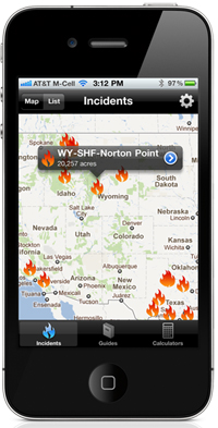
California-based FireWhat and application developer Pusher unveiled an iPhone and iPad app that consolidates federal fire, environmental and location data to provide mission-critical information to those fighting or managing wildfires.
FireWhat is a new company, founded in January 2011 by two firefighters and an MIT grad. Their mission was to bridge the gap between the fire service and technology, said co-founder Sam Lanier, who also is a fire captain with CAL FIRE. Lanier said that firefighters currently receive little to no information prior to arriving at a wildland fire so it’s important “to bring technology into a technology-deprived industry.”
The app does just that, by replicating the company’s website — a repository of information from the National Interagency Fire Center, CAL FIRE, the U.S. Forest Service, the National Weather Service, NOAA and NASA, among others. Because weather data is essential during wildfires, the app also includes a live feed from Weather Underground, a service that offers spot-weather forecasting from thousands of personal weather stations.
“In the federal database, it’s limited to NOAA or National Weather Service stations,” Lanier said. “Weather Underground offers users several thousand weather stations for more specific data.”

Agency-verified data comes into the company’s website automatically and is available immediately to iPhone users, Lanier said. On the fly, they can access active fire-perimeter mapping, weather information, fine dead fuel moisture levels and probability of ignition data. In addition, GIS mapping data comes complete with custom overlays like severe weather warnings, smoke cover, current weather conditions, perimeter tracking and more.
“On a map you can actually focus in and see the fire area, where the perimeter is and then start to allocate resources based on the data, including the winds,” he said.
FireWhat and Pusher have been working on future versions, including the addition of a fire behavior calculator that soon will help users understand how the fire will burn, in what direction and how intense the expected fire behavior may be based on inputting data into only six categories. The companies also are developing a radio-frequency function, where a user can click on a named fire and the screen will display its assigned frequency, Lanier said.
The app currently is available for iOS and costs $8.99 for download through the Apple store. However, the company is working on an Android version.


