App turns CAD texts into GPS driving directions
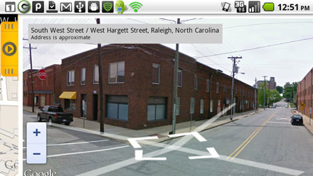
Firefighters continue to develop technologies for the fire service, this time with the FirefighterLog app available for download to Android devices. The app converts text dispatch data into Google navigator and provides firefighter-engineers with GPS-based driving directions to an incident, said Patrick Jackson, the app’s developer and a career fire engineer with the Rocky Mount (N.C.) Fire Department.
“You now can see where your fire/EMS call is when you are dispatched by text message,” Jackson said. “Many firefighters may not know where every street is in their territory — especially for volunteers — so this app can give them a quick look at where the call is and save them time as far as finding out where to go.”
When users receive a text message from dispatch, the app then displays maps of the location in conjunction with CADpage, a separate app that receives short message service (SM) pages from a centralized computer-aided dispatch system that presents options for mapping the call, driving directions and other data. Jackson said users must first download CADpage to use the FirefighterLog app.
The next version will include a radio scanner app, a list of area hydrants and other location-based features, Jackson said. It also will be available on Android tablets, not just smartphones.
“There is a lot of potential on where this can go, and I believe that we can do this at a cost that is much lower than traditional mobile data terminals,” he said.