https://urgentcomm.com/wp-content/themes/ucm_child/assets/images/logo/footer-logo.png
  • Home
  • News
  • Multimedia
    • Back
    • Multimedia
    • Video
    • Podcasts
    • Galleries
  • Commentary
    • Back
    • Commentary
    • Urgent Matters
    • View From The Top
    • All Things IWCE
    • Legal Matters
  • Resources
    • Back
    • Resources
    • Events
    • Webinars
    • White Papers
    • Reprints & Reuse
  • IWCE
    • Back
    • IWCE
    • Conference
    • Special Events
    • Exhibitor Listings
    • Premier Partners
    • Floor Plan
    • Exhibiting Information
    • Register for IWCE
  • About Us
    • Back
    • About Us
    • Contact Us
    • Advertise
    • Terms of Service
    • Privacy Statement
    • Cookies Policy
  • Related Sites
    • Back
    • American City & County
    • IWCE
    • Light Reading
    • IOT World Today
    • Mission Critical Technologies
    • Microwave/RF
    • T&D World
    • TU-Auto
  • In the field
    • Back
    • In the field
    • Broadband Push-to-X
    • Internet of Things
    • Project 25
    • Public-Safety Broadband/FirstNet
    • Virtual/Augmented Reality
    • Land Mobile Radio
    • Long Term Evolution (LTE)
    • Applications
    • Drones/Robots
    • IoT/Smart X
    • Software
    • Subscriber Devices
    • Video
  • Call Center/Command
    • Back
    • Call Center/Command
    • Artificial Intelligence
    • NG911
    • Alerting Systems
    • Analytics
    • Dispatch/Call-taking
    • Incident Command/Situational Awareness
    • Tracking, Monitoring & Control
  • Network Tech
    • Back
    • Network Tech
    • Interoperability
    • LMR 100
    • LMR 200
    • Backhaul
    • Deployables
    • Power
    • Tower & Site
    • Wireless Networks
    • Coverage/Interference
    • Security
    • System Design
    • System Installation
    • System Operation
    • Test & Measurement
  • Operations
    • Back
    • Operations
    • Critical Infrastructure
    • Enterprise
    • Federal Government/Military
    • Public Safety
    • State & Local Government
    • Training
  • Regulations
    • Back
    • Regulations
    • Narrowbanding
    • T-Band
    • Rebanding
    • TV White Spaces
    • None
    • Funding
    • Policy
    • Regional Coordination
    • Standards
  • Organizations
    • Back
    • Organizations
    • AASHTO
    • APCO
    • DHS
    • DMR Association
    • ETA
    • EWA
    • FCC
    • IWCE
    • NASEMSO
    • NATE
    • NXDN Forum
    • NENA
    • NIST/PSCR
    • NPSTC
    • NTIA/FirstNet
    • P25 TIG
    • TETRA + CCA
    • UTC
Urgent Communications
  • NEWSLETTER
  • Home
  • News
  • Multimedia
    • Back
    • Video
    • Podcasts
    • Galleries
  • Commentary
    • Back
    • All Things IWCE
    • Urgent Matters
    • View From The Top
    • Legal Matters
  • Resources
    • Back
    • Events
    • Webinars
    • White Papers
    • Reprints & Reuse
    • UC eZines
  • IWCE
    • Back
    • Conference
    • Special Events
    • Exhibitor Listings
    • Floor Plan
    • Exhibiting Information
    • Register for IWCE
  • About Us
    • Back
    • About Us
    • Contact Us
    • Advertise
    • Terms of Service
    • Privacy Statement
    • Cookies Policy
  • Related Sites
    • Back
    • American City & County
    • IWCE
    • Light Reading
    • IOT World Today
    • Mission Critical Technologies
    • Microwave/RF
    • T&D World
    • TU-Auto
  • newsletter
  • In the field
    • Back
    • Internet of Things
    • Broadband Push-to-X
    • Project 25
    • Public-Safety Broadband/FirstNet
    • Virtual/Augmented Reality
    • Land Mobile Radio
    • Long Term Evolution (LTE)
    • Applications
    • Drones/Robots
    • IoT/Smart X
    • Software
    • Subscriber Devices
    • Video
  • Call Center/Command
    • Back
    • Artificial Intelligence
    • NG911
    • Alerting Systems
    • Analytics
    • Dispatch/Call-taking
    • Incident Command/Situational Awareness
    • Tracking, Monitoring & Control
  • Network Tech
    • Back
    • Cybersecurity
    • Interoperability
    • LMR 100
    • LMR 200
    • Backhaul
    • Deployables
    • Power
    • Tower & Site
    • Wireless Networks
    • Coverage/Interference
    • Security
    • System Design
    • System Installation
    • System Operation
    • Test & Measurement
  • Operations
    • Back
    • Critical Infrastructure
    • Enterprise
    • Federal Government/Military
    • Public Safety
    • State & Local Government
    • Training
  • Regulations
    • Back
    • Narrowbanding
    • T-Band
    • Rebanding
    • TV White Spaces
    • None
    • Funding
    • Policy
    • Regional Coordination
    • Standards
  • Organizations
    • Back
    • AASHTO
    • APCO
    • DHS
    • DMR Association
    • ETA
    • EWA
    • FCC
    • IWCE
    • NASEMSO
    • NATE
    • NXDN Forum
    • NENA
    • NIST/PSCR
    • NPSTC
    • NTIA/FirstNet
    • P25 TIG
    • TETRA + CCA
    • UTC
acc.com

Public Safety


Article

Polaris tracking app keeps undercover officers undercover

Polaris tracking app keeps undercover officers undercover

Data generated by the cloud-based solution also could be useful in terms of determining the optimal utlization of traffic officers.
  • Written by
  • 19th November 2013

It is difficult for undercover police officers to remain clandestine when those around them can hear the crackle of their radios. So, they often eschew them in favor of smartphones. But abandoning their department-issued, GPS-enabled land-mobile radios makes it much more difficult for dispatchers and incident commanders to keep tabs on these officers. This is problematic during everyday operations, but especially so when officers are in foot pursuit or at events that attract a very large number of people, such as a concert or sporting event.

“When they’re going into a crowd, if they were to get into any sort of trouble, the challenge would be to find out exactly where they were,” said Chris Hsuing, a lieutenant in charge of special operations for the the Mountain View (Calif.) Police Department.

For that reason, the department recently trialed a tracking application from Polaris Wireless, dubbed Altus Blue Force, at a two-day concert that attracted about 20,000 attendees each day. Seventy officers were assigned to the event, with half in plainclothes. According to Hsuing, the event offered the perfect venue for piloting the solution, which marries the company’s Altus Mobile and Altus Command Center platforms.

“Part of the event was held in a giant parking lot,” he said.  “Even if they said that they were at a pole over here or a tree over there, it would have been very challenging to locate officers calling for help.”

Officers were given the choice of opting into the trial, for privacy reasons. The department provided the cellular phone numbers for participating officers to Polaris, which then sent the officers a text asking them to opt-in. The solution can be configured so that the officers automatically are logged out once their shift ends, to help allay any privacy issues. In the future, officers will be able to download an application to their devices that allows them to log onto the cloud-based service.

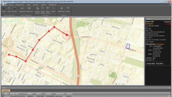
During the trial, the officers’ location information was captured by a solution developed by San Francisco–based Locaid; that data then was displayed on incident-commander screens via the Altus Blue Force application. Hsuing said it became very clear, very quickly, that app significantly improves situational awareness.

“You can kind of keep a mental picture of what’s going on by listening to the radio, but when you have a visual depiction of what’s going on, it does give you an overall better idea in your head about where all of your resources are deployed,” he said.

Bhavin Shah, vice president of marketing and business development for Mountain View-based Polaris Wireless, echoed the sentiment.

“Initially, there was a little bit of reluctance on the part of the officers to opt-in, but the captain briefed them and explained that this was for their personal safety,” Shah said. “He told them that if something were to happen — for example, if they were to get into an altercation with somebody — then they could see which officers were closest to them, and send them to help them out. … Once they saw themselves on the map, they realized [the value].”
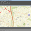
Altus Blue Force
Source: Polaris Wireless

Shah added that the ability to track plainclothes officers is perhaps even more important when they are chasing a suspect.

“Let’s say that you’re in hot pursuit of someone who runs into a building and is hiding,” he said. “The last thing you want to do is activate your radio, because you can be heard and identified,” he said. “The idea behind this is that you can be quiet but still get help without radioing in, because they’re watching your location behind the scenes at the command center.”

Shah believes that fire and emergency-medical personnel eventually could leverage the application. Meanwhile, Hsuing said that his department hasn’t decided yet whether to roll out the application on a permanent basis — but he’s already thinking about additional uses.

“We’re at a brainstorming phase right now, and one thing that we’ve thrown onto the chalkboard is giving them to our traffic officers, so that we can see where they’ve patrolled in a given week,” Hsuing said. “And then we’ll take that data and overlay it with our actual accident data, to see where the intersections are that are troubled.

“The third data set would be to see what the citizens’ perceptions are of the worst intersections,” he continued. “Those three things are not going to match up. Doing this might help us educate the public and to ensure that our traffic officers are using their time and resources in the right place. … The data might convince them to change their patrol patterns, or the routes that they typically focus on in the city.”

Tags: Incident Command Law Enforcement Personnel Tracking Public Safety Tracking, Monitoring & Control Article

Related


  • Data generated by the cloud-based solution also could be useful in terms of determining the optimal utlization of traffic officers.
  • Data generated by the cloud-based solution also could be useful in terms of determining the optimal utlization of traffic officers.
  • Data generated by the cloud-based solution also could be useful in terms of determining the optimal utlization of traffic officers.
  • Data generated by the cloud-based solution also could be useful in terms of determining the optimal utlization of traffic officers.

Leave a comment Cancel reply

To leave a comment login with your Urgent Comms account:

Log in with your Urgent Comms account

Or alternatively provide your name, email address below:

Your email address will not be published. Required fields are marked *

Related Content

  • Connected fleets and EVs could pose greatest cyber risk, says GuardKnox
  • At CES 2021, Verizon touts 5G connectivity as enabler in pandemic times
  • Federal judge reduces Hytera legal payment to Motorola Solutions by $220.9 million
  • Florida county announces successful test of Motorola Solutions' cloud-based P25 core technology

Commentary


Public safety needs a better way to triage emergency calls

13th January 2021

In challenging year, working with public safety to move FirstNet forward

30th December 2020

Communications solutions must evolve quickly to meet needs of a changing world

31st October 2020
view all

Events


UC Ezines


IWCE 2019 Wrap Up

13th May 2019
view all

Twitter


UrgentComm

Become a Thought Leader at IWCE 2021! We are looking for dynamic speakers to present case studies and technical tal… twitter.com/i/web/status/1…

26th January 2021
UrgentComm

RT @IWCEexpo: 📆 Mark Your Calendars: IWCE will be returning to Las Vegas this September and registration is slated to open in April 📆 Wa…

15th January 2021
UrgentComm

RT @IWCEexpo: ⚡FLASH SALE: Don't miss this exclusive offer! Passes to #IBFVirtual are now 50% off with code TWITTER50. Take advantage of th…

6th November 2020
UrgentComm

Get ready for part 2 of "Ensuring Public Safety Emergency Communications" next week! @PCTEL_inc will explore… twitter.com/i/web/status/1…

3rd November 2020
UrgentComm

Over the past few months, we’ve seen the world transform, and it's clear that cities will be affected in the long-t… twitter.com/i/web/status/1…

27th October 2020
UrgentComm

Florida state & local agencies subscribing to the Statewide Law Enforcement Radio System (SLERS) will be able to co… twitter.com/i/web/status/1…

26th October 2020
UrgentComm

Tune in to @slacorp CEO Josh Lober as he explains how the company has fully integrated its #PTT application to work… twitter.com/i/web/status/1…

26th October 2020
UrgentComm

.@SierraWireless announced the commercial availability of the AirLink MG90 platform, which they tout as the first m… twitter.com/i/web/status/1…

26th October 2020

Newsletter

Sign up for UrgentComm’s newsletters to receive regular news and information updates about Communications and Technology.

Expert Commentary

Learn from experts about the latest technology in automation, machine-learning, big data and cybersecurity.

Business Media

Find the latest videos and media from the market leaders.

Media Kit and Advertising

Want to reach our digital and print audiences? Learn more here.

DISCOVER MORE FROM INFORMA TECH

  • American City & County
  • IWCE
  • Light Reading
  • IOT World Today
  • Mission Critical Technologies
  • Microwave/RF
  • T&D World
  • TU-Auto

WORKING WITH US

  • About Us
  • Contact Us
  • Events
  • Careers

FOLLOW Urgent Comms ON SOCIAL

  • Privacy
  • CCPA: “Do Not Sell My Data”
  • Cookies Policy
  • Terms
Copyright © 2021 Informa PLC. Informa PLC is registered in England and Wales with company number 8860726 whose registered and Head office is 5 Howick Place, London, SW1P 1WG.
This website uses cookies, including third party ones, to allow for analysis of how people use our website in order to improve your experience and our services. By continuing to use our website, you agree to the use of such cookies. Click here for more information on our Cookie Policy and Privacy Policy.
X