https://urgentcomm.com/wp-content/themes/ucm_child/assets/images/logo/footer-new-logo.png
  • Home
  • News
  • Multimedia
    • Back
    • Multimedia
    • Video
    • Podcasts
    • Galleries
    • IWCE’s Video Showcase
    • Product Guides
  • Commentary
    • Back
    • Commentary
    • Urgent Matters
    • View From The Top
    • All Things IWCE
    • Legal Matters
  • Resources
    • Back
    • Resources
    • Webinars
    • White Papers
    • Reprints & Reuse
  • IWCE
    • Back
    • IWCE
    • Conference
    • Special Events
    • Exhibitor Listings
    • Premier Partners
    • Floor Plan
    • Exhibiting Information
    • Register for IWCE
  • About Us
    • Back
    • About Us
    • Contact Us
    • Advertise
    • Terms of Service
    • Privacy Statement
    • Cookie Policy
  • Related Sites
    • Back
    • American City & County
    • IWCE
    • Light Reading
    • IOT World Today
    • Mission Critical Technologies
    • TU-Auto
  • In the field
    • Back
    • In the field
    • Broadband Push-to-X
    • Internet of Things
    • Project 25
    • Public-Safety Broadband/FirstNet
    • Virtual/Augmented Reality
    • Land Mobile Radio
    • Long Term Evolution (LTE)
    • Applications
    • Drones/Robots
    • IoT/Smart X
    • Software
    • Subscriber Devices
    • Video
  • Call Center/Command
    • Back
    • Call Center/Command
    • Artificial Intelligence
    • NG911
    • Alerting Systems
    • Analytics
    • Dispatch/Call-taking
    • Incident Command/Situational Awareness
    • Tracking, Monitoring & Control
  • Network Tech
    • Back
    • Network Tech
    • Interoperability
    • LMR 100
    • LMR 200
    • Backhaul
    • Deployables
    • Power
    • Tower & Site
    • Wireless Networks
    • Coverage/Interference
    • Security
    • System Design
    • System Installation
    • System Operation
    • Test & Measurement
  • Operations
    • Back
    • Operations
    • Critical Infrastructure
    • Enterprise
    • Federal Government/Military
    • Public Safety
    • State & Local Government
    • Training
  • Regulations
    • Back
    • Regulations
    • Narrowbanding
    • T-Band
    • Rebanding
    • TV White Spaces
    • None
    • Funding
    • Policy
    • Regional Coordination
    • Standards
  • Organizations
    • Back
    • Organizations
    • AASHTO
    • APCO
    • DHS
    • DMR Association
    • ETA
    • EWA
    • FCC
    • IWCE
    • NASEMSO
    • NATE
    • NXDN Forum
    • NENA
    • NIST/PSCR
    • NPSTC
    • NTIA/FirstNet
    • P25 TIG
    • TETRA + CCA
    • UTC
Urgent Communications
  • NEWSLETTER
  • Home
  • News
  • Multimedia
    • Back
    • Video
    • Podcasts
    • Omdia Crit Comms Circle Podcast
    • Galleries
    • IWCE’s Video Showcase
    • Product Guides
  • Commentary
    • Back
    • All Things IWCE
    • Urgent Matters
    • View From The Top
    • Legal Matters
  • Resources
    • Back
    • Webinars
    • White Papers
    • Reprints & Reuse
    • UC eZines
    • Sponsored content
  • IWCE
    • Back
    • Conference
    • Why Attend
    • Exhibitor Listing
    • Floor Plan
    • Exhibiting Information
    • Join the Event Mailing List
  • About Us
    • Back
    • About Us
    • Contact Us
    • Advertise
    • Cookie Policy
    • Terms of Service
    • Privacy Statement
  • Related Sites
    • Back
    • American City & County
    • IWCE
    • Light Reading
    • IOT World Today
    • TU-Auto
  • newsletter
  • In the field
    • Back
    • Internet of Things
    • Broadband Push-to-X
    • Project 25
    • Public-Safety Broadband/FirstNet
    • Virtual/Augmented Reality
    • Land Mobile Radio
    • Long Term Evolution (LTE)
    • Applications
    • Drones/Robots
    • IoT/Smart X
    • Software
    • Subscriber Devices
    • Video
  • Call Center/Command
    • Back
    • Artificial Intelligence
    • NG911
    • Alerting Systems
    • Analytics
    • Dispatch/Call-taking
    • Incident Command/Situational Awareness
    • Tracking, Monitoring & Control
  • Network Tech
    • Back
    • Cybersecurity
    • Interoperability
    • LMR 100
    • LMR 200
    • Backhaul
    • Deployables
    • Power
    • Tower & Site
    • Wireless Networks
    • Coverage/Interference
    • Security
    • System Design
    • System Installation
    • System Operation
    • Test & Measurement
  • Operations
    • Back
    • Critical Infrastructure
    • Enterprise
    • Federal Government/Military
    • Public Safety
    • State & Local Government
    • Training
  • Regulations
    • Back
    • Narrowbanding
    • T-Band
    • Rebanding
    • TV White Spaces
    • None
    • Funding
    • Policy
    • Regional Coordination
    • Standards
  • Organizations
    • Back
    • AASHTO
    • APCO
    • DHS
    • DMR Association
    • ETA
    • EWA
    • FCC
    • IWCE
    • NASEMSO
    • NATE
    • NXDN Forum
    • NENA
    • NIST/PSCR
    • NPSTC
    • NTIA/FirstNet
    • P25 TIG
    • TETRA + CCA
    • UTC
acc.com

Coverage/Interference


News

Apple announces iPhone 14 lineup with Emergency SOS via Satellite, Crash Detection features

Apple announces iPhone 14 lineup with Emergency SOS via Satellite, Crash Detection features

  • Written by Donny Jackson
  • 8th September 2022

Apple yesterday announced updates to its device portfolio with new capabilities, including two that are designed to enhance the ability for customers to get help in dire circumstances: Emergency SoS via Satellite and Crash Detection.

Available with all iPhone 14 models, Emergency SOS via Satellite lets users contact emergency services via text, even when the phone is outside the coverage footprint of a cellular carrier or Wi-Fi hotspot. Expected to launch in November, Emergency SOS leverages the Globalstar network that operates on licensed 2.4 GHz spectrum known as Band 53/n53, according to an SEC filing that Globalstar released yesterday.

Connecting an iPhone that does not have an external antenna to a satellite that is hundreds of miles above the earth’s surface is a “technical challenge,” but Apple has designed a way to make it work, if there is a “clear view of the sky” and “the phone is directly pointing at a satellite,” Ashley Williams of Apple said during yesterday’s event.

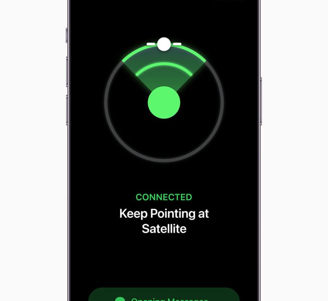
Tracking the Globalstar satellites is done with an application that is available on iPhone 14, Williams said.

“Satellites fly too high to be seen by the human eye, so we created a unique user experience that shows you where to point your phone to establish a connection and stay connected as the satellite moves,” Williams said during the event. “This way, no bulky antenna is needed [to connect to the satellite].

“Once connected, you need to send and receive enough information to get emergency help. Standard messaging protocols are not designed for satellite’s limited bandwidth, so we created a custom, short-text compression algorithm to reduce the average size of message by a factor of three.”

With a clear view of the sky, a user can transmit an Emergency SOS via Satellite text in less than 15 seconds, but a transmission could “take a few minutes” if light foliage is encumbering the link between the iPhone 14 and a satellite, according to Williams.

Given the bandwidth limitations and connectivity challenges associated with Emergency SOS via Satellite, Apple has developed an application that is designed to streamline the text communications between the user and emergency-services entity, Williams said.

“We worked with emergency experts to surface the questions they’re most likely to ask, and we provided the most common responses for you to choose from, with just a few taps,” Williams said. “With fewer messages to write and send, you can get help quicker. After a message is relayed to a ground station, it needs to reach the right emergency-service provider. If that emergency-service provider accepts text messages, we will connect you to them directly.

“If they only accept voice calls, we have set up relay centers staffed with highly trained emergency specialists ready to get your text and call an emergency-service provider on your behalf.”

This iPhone 14 satellite capability can be leveraged in non-emergency scenarios, as well.

“This breakthrough service can also be used in more casual, less dire circumstances,” Williams said. “So, if you’re out on a long hike, you can use the Find My app to share your location manually via satellite. This lets your loved ones know where you are without even sending a message.”

Emergency SOS via Satellite and other iPhone 14 satellite services are not the first satellite-direct-to-phone service to be announced, but they will be the first such services to be offered commercially at scale. It also is satellite-direct-to-phone offering that plans to leverage existing satellite spectrum, instead of utilizing spectrum licensed to a commercial wireless carrier.

T-Mobile and SpaceX recently announced joint plans to provide satellite-to-phone text, voice and some limited data in the future on T-Mobile’s 1.9 GHz airwaves. Lynk Global and AST SpaceMobile also have announced plans to build low-earth-orbit (LEO) satellite constellations and partner with cellular carriers to address outdoor coverage gaps initially via text and voice, but eventually also providing broadband services.

Lynk Global and AST SpaceMobile plan to leverage carrier-partner spectrum below 1 GHz—airwaves that have much greater signal-propagation characteristics that the 2.4 GHz that Apple will use for its service—and act as “LTE towers in space” to augment terrestrial-network coverage. SpaceX plans to provide the same capability to T-Mobile on the 1.9 GHz PCS spectrum.

Officials for Lynk, AST SpaceMobile and SpaceX have stated that users will be able to use their phones in a normal manner, as opposed to needing to point them at satellites. However, none of those companies plan to offer satellite-direct-to-phone service in the U.S. until at least next year, and all are awaiting regulatory approvals from the FCC to pursue their business plans.

In addition to the Emergency SOS via Satellite offering, Apple announced Crash Detection, a new feature on both iPhone 14 and Apple Watch that is designed to help users contact emergency-services agencies after a car crash.

“With a new dual-core accelerometer capable of detecting G-force measurements of up to 256Gs and a new high dynamic range gyroscope, Crash Detection on iPhone can now detect a severe car crash and automatically dial emergency services when a user is unconscious or unable to reach their iPhone,” according to an Apple press release. “These capabilities build on existing components, like the barometer, which can now detect cabin pressure changes, the GPS for additional input for speed changes, and the microphone,4 which can recognize loud noises typified by severe car crashes …

“When combined with Apple Watch, Crash Detection seamlessly leverages the unique strength of both devices to get users help efficiently. When a severe crash is detected, the emergency services call interface will appear on Apple Watch, as it is most likely to be in closer proximity to the user, while the call is placed through iPhone if it is in range for the best possible connection.”

Tags: homepage-featured-4 Alerting Systems Applications Companies Coverage/Interference Critical Infrastructure Dispatch/Call-taking Enterprise FCC Federal Government/Military Incident Command/Situational Awareness Interoperability Long Term Evolution (LTE) News NTIA/FirstNet Policy Power Public Safety Public-Safety Broadband/FirstNet Regional Coordination Software Standards State & Local Government Subscriber Devices System Design System Installation System Operation Test & Measurement Tower & Site Tracking, Monitoring & Control Wireless Networks News

Most Recent


  • AT&T wireless growth keyed by FirstNet—now provides 24,000 agencies with 4.4 million connections
    AT&T this week reported that FirstNet ended 2022 supporting more than 24,000 public-safety agencies with “about” 4.4 million connections, including 377,000 connections that were added during the last three months of 2022—a total that represents more than half of the carrier’s post-paid wireless growth for the quarter. AT&T officials released these figures in conjunction with […]
  • Report: Remote work causing offices to empty, but walkable cities still in high demand
    Given the reliance on vehicular transportation in the United States, some American cities historically haven’t prioritized being walkable in past planning and or design. But amid an unprecedented shift in the economy toward remote work, those that have are increasingly desirable for prospective residents. A new report from Smart Growth American and Places Platform, “Foot Traffic Ahead […]
  • AT&T FirstNet unleashes robotic dogs for emergency services
    AT&T is releasing robotic hounds from Ghost Robotics as part of the service provider’s FirstNet emergency responder service. In a blog, AT&T VP Lance Spencer explained that the robotic dogs will be connected to AT&T’s network and deployed for public safety, defense, federal and state agencies, local police and fire departments, and commercial customers. “Network-connected robotic dogs can deliver a […]
  • Federal agencies infested by cyberattackers via legit remote-management systems
    It has come to light that hackers cleverly utilized two off-the-shelf remote monitoring and management systems (RMMs) to breach multiple Federal Civilian Executive Branch (FCEB) agency networks in the US last summer. On Jan. 25, the Cybersecurity and Infrastructure Security Agency (CISA), National Security Agency (NSA), and Multi-State Information Sharing and Analysis Center (MS-ISAC) released […]

Leave a comment Cancel reply

To leave a comment login with your Urgent Comms account:

Log in with your Urgent Comms account

Or alternatively provide your name, email address below:

Your email address will not be published. Required fields are marked *

Related Content

  • T-Mobile, SpaceX unveil plans to ‘end dead zones’ and 'save lives' with satellite-direct-to-phone tech
  • Did Elon Musk just upstage Tim Cook's big iPhone 14 surprise?
  • FirstNet Authority CTO highlights coverage-extension efforts as initial Band 14 buildout nears completion
  • Lynk, AST SpaceMobile race for approvals, satellite launches

Commentary


How 5G is making cities safer, smarter, and more efficient

26th January 2023

3GPP moves Release 18 freeze date to March 2024

18th January 2023

Do smart cities make safer cities?

  • 1
6th January 2023
view all

Events


UC Ezines


IWCE 2019 Wrap Up

13th May 2019
view all

Twitter


UrgentComm

AT&T wireless growth keyed by FirstNet—now provides 24,000 agencies with 4.4 million connections dlvr.it/ShY5qH

27th January 2023
UrgentComm

Report: Remote work causing offices to empty, but walkable cities still in high demand dlvr.it/ShXM7Z

27th January 2023
UrgentComm

AT&T FirstNet unleashes robotic dogs for emergency services dlvr.it/ShW7p8

27th January 2023
UrgentComm

Federal agencies infested by cyberattackers via legit remote-management systems dlvr.it/ShVhn3

26th January 2023
UrgentComm

How 5G is making cities safer, smarter, and more efficient dlvr.it/ShVS1h

26th January 2023
UrgentComm

MCPTT interworking for critical communications dlvr.it/ShTm3P

26th January 2023
UrgentComm

Self-driving cars present terrorism risk, FBI director says dlvr.it/ShTTHx

26th January 2023
UrgentComm

UK Home Office officially will cut ESN ties with Motorola Solutions in December dlvr.it/ShNjfN

24th January 2023

Newsletter

Sign up for UrgentComm’s newsletters to receive regular news and information updates about Communications and Technology.

Expert Commentary

Learn from experts about the latest technology in automation, machine-learning, big data and cybersecurity.

Business Media

Find the latest videos and media from the market leaders.

Media Kit and Advertising

Want to reach our digital and print audiences? Learn more here.

DISCOVER MORE FROM INFORMA TECH

  • American City & County
  • IWCE
  • Light Reading
  • IOT World Today
  • Mission Critical Technologies
  • TU-Auto

WORKING WITH US

  • About Us
  • Contact Us
  • Events
  • Careers

FOLLOW Urgent Comms ON SOCIAL

  • Privacy
  • CCPA: “Do Not Sell My Data”
  • Cookie Policy
  • Terms
Copyright © 2023 Informa PLC. Informa PLC is registered in England and Wales with company number 8860726 whose registered and Head office is 5 Howick Place, London, SW1P 1WG.