https://urgentcomm.com/wp-content/themes/ucm_child/assets/images/logo/footer-new-logo.png
  • Home
  • News
  • Multimedia
    • Back
    • Multimedia
    • Video
    • Podcasts
    • Galleries
    • IWCE’s Video Showcase
    • Product Guides
  • Commentary
    • Back
    • Commentary
    • Urgent Matters
    • View From The Top
    • All Things IWCE
    • Legal Matters
  • Resources
    • Back
    • Resources
    • Webinars
    • White Papers
    • Reprints & Reuse
  • IWCE
    • Back
    • IWCE
    • Conference
    • Special Events
    • Exhibitor Listings
    • Premier Partners
    • Floor Plan
    • Exhibiting Information
    • Register for IWCE
  • About Us
    • Back
    • About Us
    • Contact Us
    • Advertise
    • Terms of Service
    • Privacy Statement
    • Cookie Policy
  • Related Sites
    • Back
    • American City & County
    • IWCE
    • Light Reading
    • IOT World Today
    • Mission Critical Technologies
    • TU-Auto
  • In the field
    • Back
    • In the field
    • Broadband Push-to-X
    • Internet of Things
    • Project 25
    • Public-Safety Broadband/FirstNet
    • Virtual/Augmented Reality
    • Land Mobile Radio
    • Long Term Evolution (LTE)
    • Applications
    • Drones/Robots
    • IoT/Smart X
    • Software
    • Subscriber Devices
    • Video
  • Call Center/Command
    • Back
    • Call Center/Command
    • Artificial Intelligence
    • NG911
    • Alerting Systems
    • Analytics
    • Dispatch/Call-taking
    • Incident Command/Situational Awareness
    • Tracking, Monitoring & Control
  • Network Tech
    • Back
    • Network Tech
    • Interoperability
    • LMR 100
    • LMR 200
    • Backhaul
    • Deployables
    • Power
    • Tower & Site
    • Wireless Networks
    • Coverage/Interference
    • Security
    • System Design
    • System Installation
    • System Operation
    • Test & Measurement
  • Operations
    • Back
    • Operations
    • Critical Infrastructure
    • Enterprise
    • Federal Government/Military
    • Public Safety
    • State & Local Government
    • Training
  • Regulations
    • Back
    • Regulations
    • Narrowbanding
    • T-Band
    • Rebanding
    • TV White Spaces
    • None
    • Funding
    • Policy
    • Regional Coordination
    • Standards
  • Organizations
    • Back
    • Organizations
    • AASHTO
    • APCO
    • DHS
    • DMR Association
    • ETA
    • EWA
    • FCC
    • IWCE
    • NASEMSO
    • NATE
    • NXDN Forum
    • NENA
    • NIST/PSCR
    • NPSTC
    • NTIA/FirstNet
    • P25 TIG
    • TETRA + CCA
    • UTC
Urgent Communications
  • NEWSLETTER
  • Home
  • News
  • Multimedia
    • Back
    • Video
    • Podcasts
    • Omdia Crit Comms Circle Podcast
    • Galleries
    • IWCE’s Video Showcase
    • Product Guides
  • Commentary
    • Back
    • All Things IWCE
    • Urgent Matters
    • View From The Top
    • Legal Matters
  • Resources
    • Back
    • Webinars
    • White Papers
    • Reprints & Reuse
    • UC eZines
    • Sponsored content
  • IWCE
    • Back
    • Conference
    • Why Attend
    • Exhibitor Listing
    • Floor Plan
    • Exhibiting Information
    • Join the Event Mailing List
  • About Us
    • Back
    • About Us
    • Contact Us
    • Advertise
    • Cookie Policy
    • Terms of Service
    • Privacy Statement
  • Related Sites
    • Back
    • American City & County
    • IWCE
    • Light Reading
    • IOT World Today
    • TU-Auto
  • newsletter
  • In the field
    • Back
    • Internet of Things
    • Broadband Push-to-X
    • Project 25
    • Public-Safety Broadband/FirstNet
    • Virtual/Augmented Reality
    • Land Mobile Radio
    • Long Term Evolution (LTE)
    • Applications
    • Drones/Robots
    • IoT/Smart X
    • Software
    • Subscriber Devices
    • Video
  • Call Center/Command
    • Back
    • Artificial Intelligence
    • NG911
    • Alerting Systems
    • Analytics
    • Dispatch/Call-taking
    • Incident Command/Situational Awareness
    • Tracking, Monitoring & Control
  • Network Tech
    • Back
    • Cybersecurity
    • Interoperability
    • LMR 100
    • LMR 200
    • Backhaul
    • Deployables
    • Power
    • Tower & Site
    • Wireless Networks
    • Coverage/Interference
    • Security
    • System Design
    • System Installation
    • System Operation
    • Test & Measurement
  • Operations
    • Back
    • Critical Infrastructure
    • Enterprise
    • Federal Government/Military
    • Public Safety
    • State & Local Government
    • Training
  • Regulations
    • Back
    • Narrowbanding
    • T-Band
    • Rebanding
    • TV White Spaces
    • None
    • Funding
    • Policy
    • Regional Coordination
    • Standards
  • Organizations
    • Back
    • AASHTO
    • APCO
    • DHS
    • DMR Association
    • ETA
    • EWA
    • FCC
    • IWCE
    • NASEMSO
    • NATE
    • NXDN Forum
    • NENA
    • NIST/PSCR
    • NPSTC
    • NTIA/FirstNet
    • P25 TIG
    • TETRA + CCA
    • UTC
acc.com

Federal Government/Military


Using radio-frequency pattern matching to nab terrorists

  • Written by
  • 4th January 2013
High-accuracy indoor location technology works extremely well in non-line-of-sight conditions, such as dense urban and indoor environments, where GPS-based solutions face severe challenges.

What is in this article?

  • Using radio-frequency pattern matching to nab terrorists
  • High-accuracy indoor location in the toolkit
  • Privacy concerns must be balanced with the need to save lives

Using radio-frequency pattern matching to nab terrorists

A version of this article appeared in the January 2013 print issue with the headline: High-stakes hide and seek.

The world was electrified in May 2011, when the US government announced the death of Osama bin Laden at the hands of a U.S. Navy SEAL unit that raided the terrorist's compound in Pakistan. In the months leading up to the raid, U.S. intelligence agencies analyzed data to create three-dimensional renderings of the house, identify residential traffic patterns, and assess the number, height and gender of the residents of the compound. Missing in all of this was the ability to locate occupants, via their mobile devices, deep in the interior of the compound (five cell phones thought to be used by bin Laden aides were seized in the raid). This lack of high-accuracy indoor location obviously did not hinder the success of the mission, but it would be useful in future national-security efforts.

Terrorists don't hide out in the open. Their network of safe houses provides some cover against increasingly pervasive satellite surveillance methods, which rely on line of sight. So, a comprehensive surveillance program must include the ability to locate terrorists with high-accuracy indoor-location technology.

In an article last year, we explored the benefits of high-accuracy indoor location for 911 and other emergency-calling needs. This article outlines how government authorities deploy software-based location solutions that are field-proven to provide high-accuracy indoor location and help thwart terrorist attacks. It also explores the technology behind these solutions, as well as the privacy concerns that must be balanced with the ability to prevent terrorism and save lives.

Viewing terrorist attacks in a new light

Let's start by considering how a high-accuracy indoor location solution could have been used prior to or during several well-known terrorist incidents where an indoor-location capability may have meant the difference between life and death:

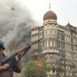
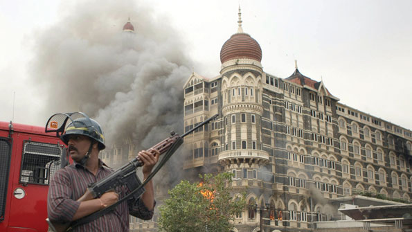
On Nov. 26, 2008, terrorists launched a coordinated series of attacks against targets in Mumbai, India, including the Taj Mahal Palace hotel. The attacks, which unfolded over three days, resulted in the deaths of 164 people and the wounding of 308 more. The terrorists maintained constant communication throughout the attacks through the use of cellular phones, smartphones and other wireless devices. Authorities could have used real-time target tracking to locate the terrorists inside the hotel and other locations.

On Jan. 24, 2011, an explosion at Domodedovo International Airport in Moscow killed at least 35 and injured more than 130 people. A suspected female terrorist reportedly triggered the bomb by opening her bag inside the international arrivals hall. Russian security agencies were reported to have received a warning prior to the attack and, with accurate indoor-location capability, could have tracked the bomber through the terminal and potentially intercepted her before she reached her target.

On Sept. 11, 2012, the U.S. consulate in Benghazi, Libya, was attacked by militants who set fire to the main building and killed the U.S. ambassador and three other members of the diplomatic mission. The attack unfolded over several hours, during which nearby security reinforcements were dispatched but were unable to locate the ambassador, who had retreated to a safe room inside the consulate. He subsequently died of smoke inhalation, but his cellular phone could have been tracked inside the building using an accurate indoor-location capability, potentially allowing him to be rescued.

High-accuracy indoor location — available at the time of these attacks and previously deployed in other countries — could have been utilized in several ways to either prevent the attacks or assist the investigations that followed, potentially altering the devastating outcomes and equipping investigators with advanced tools to help them build their cases. Having received warnings in advance of the attacks, authorities could have deployed a geo-fence (a virtual perimeter) around the target locations to alert them when identified suspects' mobile numbers approached the targets.

The combination of being able to track suspects in real time and to precisely identify sensitive areas that are off-limits is not feasible with low-accuracy location technology, because of the large number of potential suspects and the need to deploy a large number of police/military resources over the protected area. Once the attacks began, authorities could have used target tracking to identify the terrorists' locations within the hotel or airport.

In the Mumbai incident, police learned that the terrorists were relying on cellular phones and other devices to communicate with each other and their overseas handlers. Also, hotel guests were ordered to remain within their rooms during the attack, so authorities could have identified devices that were moving inside corridors or stairwells to further pinpoint the terrorists.

Only location solutions that can locate targets indoors would be useful in these scenarios. GPS (Global Positioning System) requires line of sight, so it cannot locate targets deep indoors. Moreover, criminals and terrorists don't carry GPS-enabled devices and they tend to disable, jam or spoof GPS-based location.

1 | 2 | 3 |
High-accuracy indoor location in the toolkit
Tags: Incident Command Law Enforcement Military Personnel Tracking Federal Government/Military In-Building Public Safety Tracking, Monitoring & Control Article

Leave a comment Cancel reply

To leave a comment login with your Urgent Comms account:

Log in with your Urgent Comms account

Or alternatively provide your name, email address below:

Your email address will not be published. Required fields are marked *

Related Content

  • New Orleans-area 911 center inks multiyear APEX deal with Carbyne to replace call-handling system

Commentary


How 5G is making cities safer, smarter, and more efficient

26th January 2023

3GPP moves Release 18 freeze date to March 2024

18th January 2023

Do smart cities make safer cities?

  • 1
6th January 2023
view all

Events


UC Ezines


IWCE 2019 Wrap Up

13th May 2019
view all

Twitter


UrgentComm

Public-safety coalition renews efforts to secure federal NG911 funding dlvr.it/ShwGfn

4th February 2023
UrgentComm

Newscan: Cyberattacks on DoE national labs draw lawmaker scrutiny dlvr.it/Shvpw3

3rd February 2023
UrgentComm

The shine begins to wear off 5G private wireless dlvr.it/Shth0P

3rd February 2023
UrgentComm

Phishers trick Microsoft into granting them ‘verified’ Cloud Partner status dlvr.it/Shqngn

2nd February 2023
UrgentComm

Shapeshifting robot can morph from a liquid to a solid dlvr.it/Shqk9K

2nd February 2023
UrgentComm

Automakers against stampede to BEV dominance dlvr.it/ShpX08

2nd February 2023
UrgentComm

FCC nominee Gigi Sohn headed for third Senate hearing dlvr.it/ShpDcZ

1st February 2023
UrgentComm

Sign up to learn how to successfully manage your Motorola ASTRO® 25 System: spr.ly/60143j8fp https://t.co/XcxiUwzN27

1st February 2023

Newsletter

Sign up for UrgentComm’s newsletters to receive regular news and information updates about Communications and Technology.

Expert Commentary

Learn from experts about the latest technology in automation, machine-learning, big data and cybersecurity.

Business Media

Find the latest videos and media from the market leaders.

Media Kit and Advertising

Want to reach our digital and print audiences? Learn more here.

DISCOVER MORE FROM INFORMA TECH

  • American City & County
  • IWCE
  • Light Reading
  • IOT World Today
  • Mission Critical Technologies
  • TU-Auto

WORKING WITH US

  • About Us
  • Contact Us
  • Events
  • Careers

FOLLOW Urgent Comms ON SOCIAL

  • Privacy
  • CCPA: “Do Not Sell My Data”
  • Cookie Policy
  • Terms
Copyright © 2023 Informa PLC. Informa PLC is registered in England and Wales with company number 8860726 whose registered and Head office is 5 Howick Place, London, SW1P 1WG.