New technology improves firefighter location
What is in this article?
Path to a solution
Aside from fundamental partnering and search-and-rescue techniques, incident commanders have had few options to find firefighters that are lost or disoriented, according to Jalal Mapar, program manager for DHS S&T.
"They have had no ability to track firefighters. There has been nothing — no products. Everything that works has worked outside a building with commercial GPS.
"All of these incident commanders have been operating in the dark, as far as where these guys are located inside the building. They just go entirely by radio calls."
The first technology developed by DHS S&T was the "bread crumb" approach, which called for firefighters to place small radio nodes along their path inside a building, with the nodes forming an ad-hoc mesh network that was designed to create a radio trail that would help determine location.
But this approach has many drawbacks, the biggest of which revolved around the fact that firefighters wanted to focus their energies on fighting a fire, not on establishing communications when arriving at a scene, according to Mapar.
"They really don't have time," he said. "[Firefighters] told us that they really don't want to be bothered with spending their time trying to set up base-station relays, drop bread crumbs and then make sure they're working.
"They said, 'All I want to do is have a unit that, when I turn it on, transmits my location back to the incident commander. I don't have time to wait two minutes to boot it, etc. It has to work on its own.'"
3D is the key
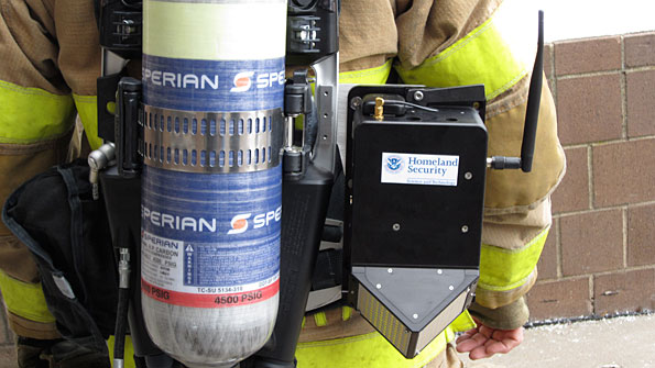
In addition to these requirements, firefighters asked DHS S&T to develop a solution that could be implemented at a scene without the help of engineers and would meet intrinsic-safety standards, Mapar said. By leveraging myriad sensor technologies (see sidebar) — many of which came from the aerospace industry to guide planes and missiles — DHS worked with Honeywell to develop GLANSER, which features units attached to a firefighter's self-contained breathing apparatus (SCBA) that operate on 900 MHz unlicensed spectrum.
With GLANSER, incident commanders are able to see a three-dimensional map that indicates the route each firefighter is taking inside a building (see photo) and includes an altitude reference point. The location information is designed to be accurate within 3 meters, which is about the height of a normal floor in a multi-story building. The graphical interface does not state what floor a firefighter is on, but it does indicate whether a firefighter has gone up or down stairs relative to the point at which he entered the building.
"That ability to get that third-dimensional view of the building is truly the difference maker in this technology," said John Sullivan, deputy chief of the Worchester, Mass., fire department, which participated in a demonstration of GLANSER this summer.
Another key feature of GLANSER is that it did not interfere with normal firefighter operations and did not require any engineers to operate — something Worchester fire officials mandated for the demonstration, according to Mapar. The only DHS S&T personnel allowed on the site were in the incident-command area to answer questions about features and capabilities, he said.
Sullivan was impressed with the demonstration.
"It worked very well. The GLANSER technology is right where we expected it to be. The advancements in the communication pieces and the ability to track on that third dimension have truly advanced a long way, to the point where we're pretty confident in the technology and being able to use it.
"As you know, in the fire service, having confidence in the technology is huge."


Are you kidding? “GPS only
Are you kidding? “GPS only provides longitude and latitude (X and Y) coordinates?” REALLY?
Two questions: How many variations of lat/long are there and why are none of them the STANDARD for ground responders? What is the U.S. civil standard grid reference system? Third question, why?
It’s just sad. Non-standards based approach by S&T will mean non-interoperability for many more years to come. Hose fittings all over again but in a technological sense.
To minimize operational friction during all phases of the emergency management lifecycle, but especially during the response phase, first responders and others (including military assets supporting civil authorities) require the ability to use and exchange standardized map coordinates. The lack of a similar, standardized procedure by state, local, and many Federal Agencies is a critical deficiency in U.S. consequence management.
Really it’s the first step in
Really it’s the first step in using this technology. Why criticize something you have never tried. It’s not a finished product and in the next 2-3 years it will likely change again. Relax.
Well, first off, GPS really
Well, first off, GPS really is only accurate for X and Y coordinates and provides questionable altitude information. Since satellites are liable to be anywhere along the horizon at any time, altitude performance is not effective and the final point, stated in the article, is that GPS does not work well in buildings – especially high-rises.
Agreed, though, that the data should still be transmitted in a standardized way, or even better, open-source so that while RF encryption still secures the data, the data can be read by authorized people such as developers who can build their technologies to interoperate based off of the same communications protocol.
If GPS only provides long.
If GPS only provides long. lat. (x,y) data and not altitude data, (z axis) why is it used in aviation? Do your due diligence Donny.