https://urgentcomm.com/wp-content/themes/ucm_child/assets/images/logo/footer-logo.png
  • Home
  • News
  • Multimedia
    • Back
    • Multimedia
    • Video
    • Podcasts
    • Galleries
  • Commentary
    • Back
    • Commentary
    • Urgent Matters
    • View From The Top
    • All Things IWCE
    • Legal Matters
  • Resources
    • Back
    • Resources
    • Events
    • Webinars
    • White Papers
    • Reprints & Reuse
  • IWCE
    • Back
    • IWCE
    • Conference
    • Special Events
    • Exhibitor Listings
    • Premier Partners
    • Floor Plan
    • Exhibiting Information
    • Register for IWCE
  • About Us
    • Back
    • About Us
    • Contact Us
    • Advertise
    • Terms of Service
    • Privacy Statement
    • Cookies Policy
  • Related Sites
    • Back
    • American City & County
    • IWCE
    • Light Reading
    • IOT World Today
    • Mission Critical Technologies
    • Microwave/RF
    • T&D World
    • TU-Auto
  • In the field
    • Back
    • In the field
    • Broadband Push-to-X
    • Internet of Things
    • Project 25
    • Public-Safety Broadband/FirstNet
    • Virtual/Augmented Reality
    • Land Mobile Radio
    • Long Term Evolution (LTE)
    • Applications
    • Drones/Robots
    • IoT/Smart X
    • Software
    • Subscriber Devices
    • Video
  • Call Center/Command
    • Back
    • Call Center/Command
    • Artificial Intelligence
    • NG911
    • Alerting Systems
    • Analytics
    • Dispatch/Call-taking
    • Incident Command/Situational Awareness
    • Tracking, Monitoring & Control
  • Network Tech
    • Back
    • Network Tech
    • Interoperability
    • LMR 100
    • LMR 200
    • Backhaul
    • Deployables
    • Power
    • Tower & Site
    • Wireless Networks
    • Coverage/Interference
    • Security
    • System Design
    • System Installation
    • System Operation
    • Test & Measurement
  • Operations
    • Back
    • Operations
    • Critical Infrastructure
    • Enterprise
    • Federal Government/Military
    • Public Safety
    • State & Local Government
    • Training
  • Regulations
    • Back
    • Regulations
    • Narrowbanding
    • T-Band
    • Rebanding
    • TV White Spaces
    • None
    • Funding
    • Policy
    • Regional Coordination
    • Standards
  • Organizations
    • Back
    • Organizations
    • AASHTO
    • APCO
    • DHS
    • DMR Association
    • ETA
    • EWA
    • FCC
    • IWCE
    • NASEMSO
    • NATE
    • NXDN Forum
    • NENA
    • NIST/PSCR
    • NPSTC
    • NTIA/FirstNet
    • P25 TIG
    • TETRA + CCA
    • UTC
Urgent Communications
  • NEWSLETTER
  • Home
  • News
  • Multimedia
    • Back
    • Video
    • Podcasts
    • Galleries
  • Commentary
    • Back
    • All Things IWCE
    • Urgent Matters
    • View From The Top
    • Legal Matters
  • Resources
    • Back
    • Events
    • Webinars
    • White Papers
    • Reprints & Reuse
    • UC eZines
  • IWCE
    • Back
    • Conference
    • WHY ATTEND
    • Exhibitor Listings
    • Floor Plan
    • Exhibiting Information
    • Registration Opens April 2019-Join Our Mailing List
  • About Us
    • Back
    • About Us
    • Contact Us
    • Advertise
    • Terms of Service
    • Privacy Statement
    • Cookies Policy
  • Related Sites
    • Back
    • American City & County
    • IWCE
    • Light Reading
    • IOT World Today
    • TU-Auto
  • newsletter
  • In the field
    • Back
    • Internet of Things
    • Broadband Push-to-X
    • Project 25
    • Public-Safety Broadband/FirstNet
    • Virtual/Augmented Reality
    • Land Mobile Radio
    • Long Term Evolution (LTE)
    • Applications
    • Drones/Robots
    • IoT/Smart X
    • Software
    • Subscriber Devices
    • Video
  • Call Center/Command
    • Back
    • Artificial Intelligence
    • NG911
    • Alerting Systems
    • Analytics
    • Dispatch/Call-taking
    • Incident Command/Situational Awareness
    • Tracking, Monitoring & Control
  • Network Tech
    • Back
    • Cybersecurity
    • Interoperability
    • LMR 100
    • LMR 200
    • Backhaul
    • Deployables
    • Power
    • Tower & Site
    • Wireless Networks
    • Coverage/Interference
    • Security
    • System Design
    • System Installation
    • System Operation
    • Test & Measurement
  • Operations
    • Back
    • Critical Infrastructure
    • Enterprise
    • Federal Government/Military
    • Public Safety
    • State & Local Government
    • Training
  • Regulations
    • Back
    • Narrowbanding
    • T-Band
    • Rebanding
    • TV White Spaces
    • None
    • Funding
    • Policy
    • Regional Coordination
    • Standards
  • Organizations
    • Back
    • AASHTO
    • APCO
    • DHS
    • DMR Association
    • ETA
    • EWA
    • FCC
    • IWCE
    • NASEMSO
    • NATE
    • NXDN Forum
    • NENA
    • NIST/PSCR
    • NPSTC
    • NTIA/FirstNet
    • P25 TIG
    • TETRA + CCA
    • UTC
acc.com

Incident Command/Situational Awareness


News

Jurisdiction View feature from RapidSOS a ‘game-changer’ for Arizona PSAP

Jurisdiction View feature from RapidSOS a ‘game-changer’ for Arizona PSAP

  • Written by Donny Jackson
  • 28th February 2020

RapidSOS yesterday announced the general availability of its new Jurisdiction View module, which quickly displays enhanced location information and other data associated with all 911 calls within the jurisdiction of a public-safety answering point (PSAP) on a map interface that is being described as a “game-changer” for at least one 911 center.

Included in the RapidSOS Portal software application that is free to PSAPs, the Jurisdiction View feature provides a map depicting the location and other information associated with an emergency caller—provided by RapidSOS input providers like Apple, Google, Uber and MedicAlert—in real time, according to Tom Guthrie, senior vice president and general manager of public safety at RapidSOS.

“We are showing them where we have from a [911] caller,” Guthrie said during an interview with IWCE’s Urgent Communications. “It’s not the calls, because we’re not a call-taking system; we are supplementary data to the calls.

“So, the dots on the map that you’re seeing [within Jurisdiction View] are the appearance of data from our clearinghouse from our input providers. It gives you a full view of your jurisdiction and the distribution of those calls coming in. That’s the situational-awareness piece.”

While RapidSOS also provides this caller information through its Query View, which lets 911 personnel collect data sent by RapidSOS associated with the 911 caller’s number, the Query View requires the telecommunicator to wait until the call is received to make the query. With Jurisdiction View, the information from RapidSOS is delivered to the PSAP automatically and quickly—typically before the phone rings in the 911 center.

“Jurisdiction View delivers to you,” Michelle Potts, communications manager for the Chandler (Ariz.) police department, said during an interview with IWCE’s Urgent Communications. “We keep Jurisdiction View up; everybody logs in at the beginning of their shift. Really, that is our 911 tool. We have our 911 map, we use ANI/ALI, we use our integrated solution, too. The direction that we’ve given everyone is, ‘Make good decisions, based on the information that’s put in front of you.’

“Every situation is going to be different, but we have found that the [Jurisdiction View] portal is giving us really great information.”

Potts said that the Chandler 911 center has been a been a beta customer using Jurisdiction View since early 2019, and the operational impact have been significant.

“Jurisdiction View actually provided so much more information that it was pretty much a game-changer,” she said.

“What we like is that … the enhanced data that is in there—like MedicAlert and Uber—is all in one central place. It’s kind of a dashboard for anything that’s coming.

“Any other enhanced data that is going to provide additional information for emergency services can sit on the portal and be delivered on a 911 call. So, if you want to report an emergency, however that is—Internet of Things—it’s unlimited, and it’s all in one place.”

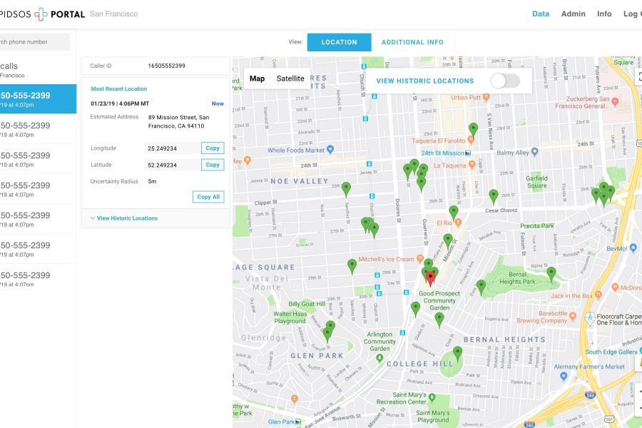
Potts also noted the quality and fast delivery of the information, which is depicted on a map in near real time and includes features such as “breadcrumb” location tracking of a 911 caller on the move.

“On a 911 call, historically you just have one dot—you have a pin on a map that says, ‘We think it’s here, and the caller could be within this radius,’” Potts said. “With the [Jurisdiction View] portal, we have this location, we have the uncertainty radius—and we’re seeing a lot 5- to 10-meter radius—and now we’re seeing them move. We see these red pins moving on this map, and we’re seeing … in near real time where that caller actually is.

“If somebody’s driving down the road, we can see what intersection they’re approaching. We can see that they’re approaching this intersection, and we can give them directions on where to turn or to go through the intersection. We could relay that information to our first responders, so they can kind of get ahead of it, and we can close that time gap between the call-taker entering the information and the dispatcher relaying that information to the officers.”

Having reliable location data for an emergency caller depicted on a map in near real time has impacted the manner in which the Chandler telecommunicators interact with callers, as Potts noted in an example of a domestic-violence victim who called 911 but was too traumatized to speak.

“When [the victim is] not able to communicate, and all of a sudden, she starts running and we can see the dots on the screen moving, the call-taker no longer has to say, ‘Which way are you going?’ and ‘Where are you at?’” Potts said. “We change our questions to be with the caller, and we can change our questions to find where the suspect is at, what kind of weapons are being used—more of the safety questions, rather than the basic questions that are sometimes impossible to get information from a victim who has been traumatized like that.

“In this case, this female was running down the street. Knowing that she is running west or east, that is a big difference. [With Jurisdiction View] we don’t even have to ask that in that moment. We’re more concerned about where is he [the suspected abuser] and things like that. It really expedites it.”

Many telecommunicators have expressed a fear that the addition of new data types could result in “information overload” that could distract call-takers from focusing on the emergency caller’s needs, particularly if a graphic video of an incident accompanied an emergency call.

Potts said the additional data provided by the RapidSOS platform has not been problematic for the Chandler 911 center.

“I think it makes us more efficient,” Potts said. “If we’re looking at the dots, and we can give better directions, then we don’t have to ask 72 questions anymore. We can look at the dots and we can give way more efficient, quality information that lead to better decisions … instead of having to go through this audible process of ‘What are you seeing?’ ‘What am I seeing?’ and how am I interpreting it in between. We cut down that time, and we’re may more efficient that way, even when things are kind of confusing.

“Over the long haul, in terms of adding things, as long as we continue to add it to the same place … I think we’ll be fine. I do think we save time, as long as we’re doing things efficiently.”

Potts and Guthrie said that Jurisdiction View also has delivered some promising results associated with a longstanding 911 problem—the use of non-service-initialized (NSI) phones.

“In a lot of cases, the call [from an NSI phone] going through the carrier path won’t show a number that’s assigned to that device; it will just say that it’s coming in from 911,” Guthrie said. “But, in some cases, we can actually see a 10-digit number that can be used to call them back, which is really unique.

“Some of the data that we’re able to get back directly from the device is more accurate at times than what might make it through the call path in the ANI/ALI feed.”

Similarly, Jurisdiction View can be used as a tool that helps a 911 center get help to citizens, even after suffering an outage to the traditional local 911 infrastructure, according to Guthrie.

“Even if the call doesn’t go through, the fact that a call was attempted may well go through for us,” Guthrie said. “So, even if you’ve got a temporary outage, you’re going to see data that came in about call attempts. If a PSAP still had outbound, 10-digit calling, they could call those callers back.


Tags: homepage-featured-4 Alerting Systems Applications Companies Dispatch/Call-taking Funding Incident Command/Situational Awareness Internet of Things Interoperability IoT/Smart X News NG-911 Policy Public Safety Regional Coordination State & Local Government System Design System Operation Tracking, Monitoring & Control News

Related


  • Avaya announces availability of MLTS location capabilities through integration with RapidSOS, 911 Secure
    Emergency calls from multi-line telephone systems (MLTS) can include better location and situational-awareness information, thanks to integration work between Avaya, RapidSOS and 911 Secure that is now commercially available to enterprises—and is available for use by other 911 vendors, if they want. Avaya recently announced the commercial availability of the location enhancement, which leverages Avaya’s […]
  • Location Services: Why Can’t 911 Find Me But My Rideshare Can?
    Examine how partnerships with operators, emergency responders and municipalities are working to address this issue and how new technologies are changing the paradigm.
  • RapidSOS, MedicAlert partner to enable sharing of key patient information during emergencies
    First responders could have access to information about a victim’s medical background during an incident before trying to render aid, thanks to a partnership announced yesterday between RapidSOS and the MedicAlert Foundation that would let MedicAlert members’ information be sent to 911. RapidSOS is best known for providing accurate location information about 911 callers to […]
  • RapidSOS partners with Google to deliver improved wireless 911 caller location to PSAPs
    RapidSOS this week announced a partnership with Google to deliver Android Emergency Location Service (ELS) information to public-safety answering points (PSAPs) for free, providing U.S. 911 centers with a method to access improved wireless-caller location much more quickly to enhance incident-response efforts.

Leave a comment Cancel reply

To leave a comment login with your Urgent Comms account:

Log in with your Urgent Comms account

Or alternatively provide your name, email address below:

Your email address will not be published. Required fields are marked *

Related Content

  • What we know (and don't know) so far about the 'Supernova' SolarWinds attack
  • Biden's big infrastructure plan targets broadband access, puts subsidy programs on notice
  • AT&T launches 5G services for FirstNet subscribers in parts of 38 cities, 20+ venues
  • Newscan: Virginia State Police admit—after repeated denials—they used controversial facial-recognition app

Commentary


Unlocking the power of ESInets: Different NG911 provisioning approaches exist; level of control is key differentiator

7th April 2021

Ransomware? Let’s call it what it really is: extortionware

21st February 2021

Redefining communications for today’s mobile workforces

18th February 2021
view all

Events


UC Ezines


IWCE 2019 Wrap Up

13th May 2019
view all

Twitter


UrgentComm

Newscan: Single sign-in for government services expands to states, localities dlvr.it/RxLQNR

9th April 2021
UrgentComm

‘Life-saving technology’: AST SpaceMobile CEO outlines capabilities of direct-to-smartphone LEO satellite service dlvr.it/RxKqvp

9th April 2021
UrgentComm

Handcuffs over AI: Solving security challenges with law enforcement dlvr.it/RxGtpD

8th April 2021
UrgentComm

Fujistsu: Cyber cretins are casing out private 5G dlvr.it/RxGnfN

8th April 2021
UrgentComm

Faster in-vehicle Wi-Fi dependent on faster connectivity dlvr.it/RxGnZL

8th April 2021
UrgentComm

Digital-health infrastructure benefits from cloud-to-edge architecture dlvr.it/RxFcjx

8th April 2021
UrgentComm

All actions monitored: The 10 most surveilled major cities in the U.S. dlvr.it/RxFZHV

8th April 2021
UrgentComm

Unlocking the power of ESInets: Different NG911 provisioning approaches exist; level of control is key differentiat… twitter.com/i/web/status/1…

7th April 2021

Newsletter

Sign up for UrgentComm’s newsletters to receive regular news and information updates about Communications and Technology.

Expert Commentary

Learn from experts about the latest technology in automation, machine-learning, big data and cybersecurity.

Business Media

Find the latest videos and media from the market leaders.

Media Kit and Advertising

Want to reach our digital and print audiences? Learn more here.

DISCOVER MORE FROM INFORMA TECH

  • American City & County
  • IWCE
  • Light Reading
  • IOT World Today
  • Mission Critical Technologies
  • Microwave/RF
  • T&D World
  • TU-Auto

WORKING WITH US

  • About Us
  • Contact Us
  • Events
  • Careers

FOLLOW Urgent Comms ON SOCIAL

  • Privacy
  • CCPA: “Do Not Sell My Data”
  • Cookies Policy
  • Terms
Copyright © 2021 Informa PLC. Informa PLC is registered in England and Wales with company number 8860726 whose registered and Head office is 5 Howick Place, London, SW1P 1WG.
This website uses cookies, including third party ones, to allow for analysis of how people use our website in order to improve your experience and our services. By continuing to use our website, you agree to the use of such cookies. Click here for more information on our Cookie Policy and Privacy Policy.
X